Longdendale Trail - hike up to the moor heights
- Written by Portal Editor

After exploring the Longdendale Trail in sections along the reservoirs and at the Woodhead tunnels by e-bike, we were drawn to the high plains of this part of the Pennines, also known as the backbone of England.
Although there are some broad passages through the Pennines for long-distance traffic and couple of dirt roads that can be climbed by bicycle, but these are usually in connection with the car traffic and due to that not pleasant to use. A few miles after the Woodhead tunnels, we had discovered a narrow trail that we wanted to use to climb up during a hike.
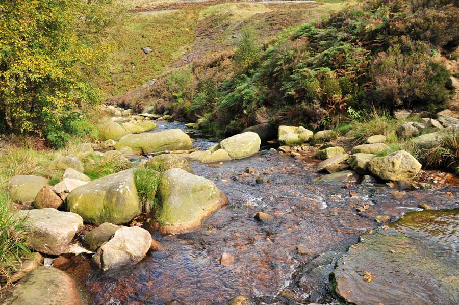
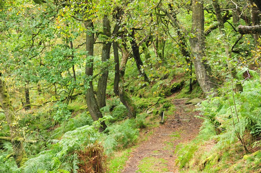
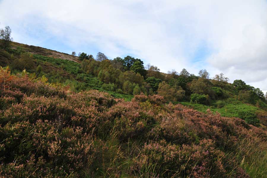
At first along a creek, the rippling accompanied us for a while, almost like a valley with dense trees, in between some man-sized ferns, then the way was steeper and was just little attached, the trees were increasingly lighter. Moose covered the trees, almost ghostly the scenery (see picture gallery). And then suddenly ..... no more trees only huge moor areas in front of the eyes.
 Incidentally, the Pennines are approximately 400 km of low mountain ranges that range from the Peak District in the Midlands to parts of Greater Manchester, the Yorkshire Dales, the West Pennine Moors in Lancashire and the Cumbria Fells to the Cheviot Hills to the Scottish border. And despite their relatively low altitude, the Pennines are widely regarded as one of the most scenic areas in Britain. The landscape is generally made up of bogs, criss-crossed by the fertile river valleys. The area is very sparsely populated for English conditions, even miles without any housing. To the east of the Pennines are the cities of Bradford, Leeds and Sheffield and to the west Manchester and Glossop, to name just a few. Main industries of the local population are sheep breeding, countless quarries and increasingly tourism, especially in the field of outdoor hiking and cycling or mountain biking.
Long distance trail Pennine Way of increasing importance
The now wellknown Pennine Way is a longdistance trail that crosses the Pennines from south to north. It has a length of 429 kilometers and stretches from Edale (Derbyshire) in the Peak District through the Yorkshire Dales and Northumberland National Park. The Pennine Way ends at Kirk Yetholm just across the border with Scotland. Along with Hadrian's Wall Path and the West Highland Way, the Pennine Way is one of Britain's most popular hiking trails. After the South West Coast Path, it is the second longest of the developed trails in the United Kingdom.
 The Pennine Way runs through sparsely populated areas. Partly there are little to no refreshments during the daily stages, also accommodation options are in places scarce, in bad weather conditions it is a difficult trail. There is also no dense route marking, so that hikers in places rely on map and compass or GPS. Accommodation options include smaller hotels, youth hostels and bed and breakfast accommodation. The combination of hiking and cycling with the use of the mini-caravan BTurtle is therefore a real option for those who not just want to "complete" the long-distance hiking trail, but also enjoy nature and solitude. Good independent care and weatherproof clothing is provided. The parts of the Pennine Way explored on the so-called Longdendale Trail are excellently suited for this purpose.
The long-distance trail was the brainchild of journalist Tom Stephenson, who used similar trails in the United States, especially the Appalachian Trail. Stephenson publicized his plan in the 1935 Daily Herald and lobbied Parliament. The last leg of the journey and probably the most difficult stage was opened in 1965 at Malham.
Malham Cove - walk through fantastic limestone formations
Malham Cove is a natural limestone formation reminiscent of the last Ice Age near the British town of Malham in North Yorkshire. It consists of a rugged limestone surface, which slopes vertically on its south side almost in the form of an amphitheater, in the valley below. The wall is 80 meters high and 300 meters wide.
 Originally a waterfall crashed over the cliff fed by the outflow of the north Malham Tarn. Since the melting of the glaciers, however, this drain sinks in the ground after just a few hundred meters; the other valley is still cut into the terrain but is usually dry. For a long time it was thought that the sunken water is the source that springs from the bottom of Malham Cove. However, it has been shown by dyeing that this is not the case.
After heavy rainfall in December 2015, the dry bed was so full that on December 6, 2015, water fell over the cliff again.
Malham Cove is crossed by the Pennine Way, which runs up through the dry valley and down the Malham Beck.
The steep limestone wall has been climbed since the 1950s and is considered one of the most important and difficult sports climbing destinations on the British Isle. The most challenging routes "Rainshadow" 9a and "Overshadow" 9a + (both French Difficulty Scale) by Steve McClure are among the toughest climbing routes in the UK.
Please read as well:
Biking and Hiking Longdendale Trail to Woodhead Tunnel
Longdendale Trail along the Shelf Moor Bleaklow
-
 Longdendale Trail meeting Pinnine Way
Longdendale Trail meeting Pinnine Way
Longdendale Trail meeting Pinnine Way
-
Longdendale Trail meeting Pinnine Way
Longdendale Trail meeting Pinnine Way
-
Longdendale Trail meeting Pinnine Way
Longdendale Trail meeting Pinnine Way
-
 Longdendale Trail meeting Pinnine Way
Longdendale Trail meeting Pinnine Way
Longdendale Trail meeting Pinnine Way
-
Longdendale Trail meeting Pinnine Way
Longdendale Trail meeting Pinnine Way
-
Longdendale Trail meeting Pinnine Way
Longdendale Trail meeting Pinnine Way
-
Longdendale Trail meeting Pinnine Way
Longdendale Trail meeting Pinnine Way
-
Longdendale Trail meeting Pinnine Way
Longdendale Trail meeting Pinnine Way
-
Longdendale Trail meeting Pinnine Way
Longdendale Trail meeting Pinnine Way
-
Longdendale Trail meeting Pinnine Way
Longdendale Trail meeting Pinnine Way
-
Longdendale Trail meeting Pinnine Way
Longdendale Trail meeting Pinnine Way
-
Longdendale Trail meeting Pinnine Way
Longdendale Trail meeting Pinnine Way
-
Longdendale Trail meeting Pinnine Way
Longdendale Trail meeting Pinnine Way
-
Longdendale Trail meeting Pinnine Way
Longdendale Trail meeting Pinnine Way
-
Longdendale Trail meeting Pinnine Way
Longdendale Trail meeting Pinnine Way


https://www.alaturka.info/en/bicycle-travelling-e-bike-camping/4929-longdendale-trail-hike-up-to-the-moor-heights?tmpl=component&print=1&layout=default#sigProIdd39b56dfb3