With the Ruhrtal ferry boat to the castle ruins Hardenstein
- Written by Portal Editor

Once again on the way between the lock Herbede and the castle ruin Hardenstein on the Ruhr Valley cycle path, the ferry Hardenstein forms a possibility to cross the Ruhr, whereby the ferry closes the gap in the strongly frequented bicycle net along the Ruhr.
In discussions with the operator, we had learned that initially a small ferry had been in use for years. With the increase in the number of cyclists, such a high utilization had been achieved that even waiting times at the ferry had resulted. The time had come for a larger ferry. As early as in 1883 already, there was a connection via the Ruhr by rowboat at this point. In the fifties of the last century, boats man Rosendahl recently brought day trippers across the Ruhr.
The castle ruins Hardenstein as a stopover
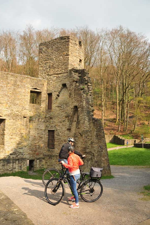
 On the way to the ferry, the castle Hardenstein forms the background of the here quite idyllic posing river course of the Ruhr, it is even surrounded by the homonymous nature reserve Hardenstein. Until the completion of the Ruhr Valley Railway, which today serves as a museum railway, the castle was located directly on the riverbank. Typologically, the castle has long been known as a castle rather than a "solid house" - that is to consider a mansion. It served mainly as the residence of his lordly owners and was only partially built for defensive.
In 1354 Henry II of Hardenberg had to sell the Castle Hardenberg in today's Velbert to Count Gerhard I of Jülich-Berg. In the same year, Henry II of Hardenberg settled with his family on the southern bank of the Ruhr between Herbede and Witten. The moated castle was built between 1345 and 1354.
Its descendants called themselves from Hardenstein and probably suffered from many financial worries. In 1378 Heinrich IV von Hardenstein instigated a feud against the city of Dortmund because he was owing a large sum of money to a Jewish businessman. The attack with about 1,000 men on the city of Dortmund failed. In another subsequent campaign he was caught by the Cologne troops and executed little later.
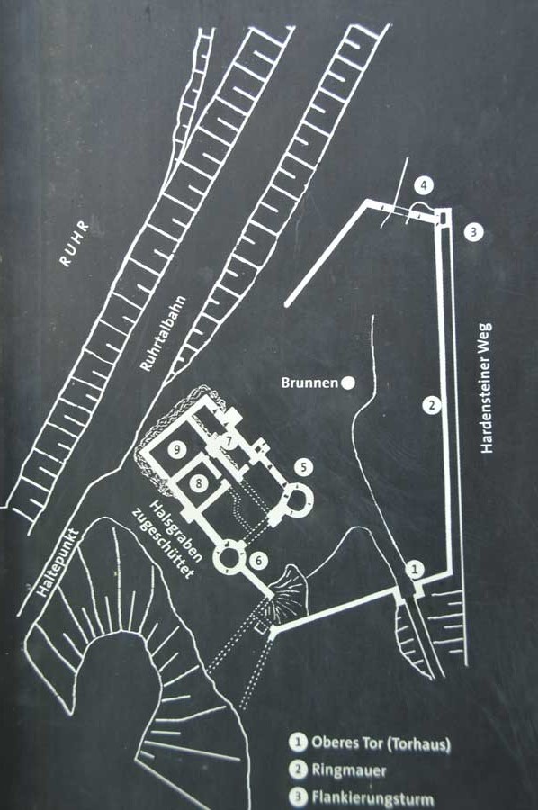
Mantle wall and two flanking towers
 1430/40 the south side was extended with two flanking towers and a shield wall. As shield wall the highest and strongest castle wall is called then, when it is set off clearly from the remainder of the enclosing walls. The shield wall serves to secure the main attack side. If a shield wall stretched over two or more sides, one speaks of the high mantle or mantle wall.
A clear definitional demarcation from the mantle wall is often not possible. The construction of shield walls became common in the late 12th century and might be seen as a reaction to the increasing use of heavy siege engines such as the Blide. The strength of a shield wall could in extreme cases be up to twelve meters high (Neuscharfeneck Castle). On the mural crown usually ran a battlement, the shield wall could be edged by two towers as well. In some cases, the shield wall replaced the water, such as in the ruins located in Westerwald Sporkenburg or the ruin Alt-Eberstein near Baden-Baden. In other cases, for example, at the castle Liebenzell, the keep was fitted in the center of the shield wall.
The legend of Goldemar
 Legend tells that at the time of a Neveling of Hardenstein a dwarf king named Goldemar or Volmar, who was invisible, lived in the castle as his guest. All inhabitants dined, drank and celebrated together. After the kitchen boy had sprinkled peas and flour on the ground to at least see the footprints of the Dwarven King, the Dwarf King killed, boiled and devoured him and disappeared, not without imposing a curse on the family.
Surroundings and mining trail Muttental
Immediately following the southern enclosure wall the mining trail Muttental starts; on the north side runs the route of the RuhrtalBahn museum railway, which separates the castle complex from the Ruhr. Here another breakpoint is quite impressive.
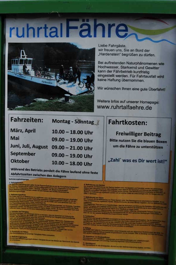
Ferry times for the season 2019:
Season: March 25th to October 31st
March, April and October: daily 10.00-18.00
May and September: daily 9.00-19.00
June, July and August: daily 9.00-21.00
Capacity: max. 50 people
Coordinates: 51 ° 25 '14.6 "N, 7 ° 18' 5.4" O
Height: 95 m above sea level. NN
Please read as well:
Short walk along the Kemnader Lake - spring air lures
Route of industrial culture by bike and BTurtle
-
 Biking Route Ruhrtal - Crossing the Ruhr
Biking Route Ruhrtal - Crossing the Ruhr
Biking Route Ruhrtal - Crossing the Ruhr
-
Biking Route Ruhrtal - Crossing the Ruhr
Biking Route Ruhrtal - Crossing the Ruhr
-
 Biking Route Ruhrtal - Crossing the Ruhr
Biking Route Ruhrtal - Crossing the Ruhr
Biking Route Ruhrtal - Crossing the Ruhr
-
Biking Route Ruhrtal - Crossing the Ruhr
Biking Route Ruhrtal - Crossing the Ruhr
-
Biking Route Ruhrtal - Crossing the Ruhr
Biking Route Ruhrtal - Crossing the Ruhr
-
Biking Route Ruhrtal - Crossing the Ruhr
Biking Route Ruhrtal - Crossing the Ruhr
-
Biking Route Ruhrtal - Crossing the Ruhr
Biking Route Ruhrtal - Crossing the Ruhr
-
Biking Route Ruhrtal - Crossing the Ruhr
Biking Route Ruhrtal - Crossing the Ruhr
-
Biking Route Ruhrtal - Crossing the Ruhr
Biking Route Ruhrtal - Crossing the Ruhr
-
Biking Route Ruhrtal - Crossing the Ruhr
Biking Route Ruhrtal - Crossing the Ruhr
-
Biking Route Ruhrtal - Crossing the Ruhr
Biking Route Ruhrtal - Crossing the Ruhr
-
Biking Route Ruhrtal - Crossing the Ruhr
Biking Route Ruhrtal - Crossing the Ruhr
-
Biking Route Ruhrtal - Crossing the Ruhr
Biking Route Ruhrtal - Crossing the Ruhr
-
Biking Route Ruhrtal - Crossing the Ruhr
Biking Route Ruhrtal - Crossing the Ruhr
-
Biking Route Ruhrtal - Crossing the Ruhr
Biking Route Ruhrtal - Crossing the Ruhr
-
Biking Route Ruhrtal - Crossing the Ruhr
Biking Route Ruhrtal - Crossing the Ruhr
-
Biking Route Ruhrtal - Crossing the Ruhr
Biking Route Ruhrtal - Crossing the Ruhr
-
Biking Route Ruhrtal - Crossing the Ruhr
Biking Route Ruhrtal - Crossing the Ruhr


