Beyşehir
Beyşehir is a large town and district of Konya Province in the Central Anatolia region of Turkey. The town is located on the south eastern shore of Lake Beyşehir and is marked to the west and the southwest by the steep lines and forests of the Taurus Mountains, while a fertile plain, an extension of the lake area, extends in the south eastern direction.
According to 2000 census, population of the district is 118,144 of which 41,312 live in the town of Beyşehir.
Beyşehir region corresponds to classical antiquity's Pisidia. At the location of the town itself, there was in all likelihood an ancient city, probably named Karallia, which was one of the two urban centres that surrounded the lake at the time. The same centre would have been re-named in Byzantine times.
The ancient city's state of desolation in the first decades of the 13th century is suggested by the name "Viranşehir" that the Seljuk Turks had given to the town, meaning "the desolate city". The Seljuk Sultans of Rum based in Konya nevertheless built their summer residence nearby, in an agglomeration situated on the south western lake shore at a distance of 80 km (50 mi) from Beyşehir city, and which came to be known as Kubadabad Palace. While the most precious finds of Kubadabad site date from the reign of Alaeddin Keykubad (1220-1237), it was a seasonal settlement area chosen by and for the sultans already in the late 12th century.
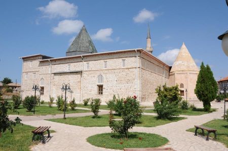
After the fall of the Seljuks, Viranşehir was re-named for a time as Süleymanşehir in honour of one of the Beys of the region's ruling dynasty, the Eşrefoğlu, who made the town into his capital. Since the Beys of Eşrefoğlu resided here, the present name of Beyşehir was gradually adopted for the town. The Great Mosque of Beyşehir built by the dynasty between 1296-1299, also called Eşrefoğlu Mosque, is considered one of the masterpieces of the intermediate period of Anatolian beyliks between the Seljuk and Ottoman architecture styles.HAZAR
The Hittite monument situated in Beyşehir's depending locality of Eflatun Pınar, at a short distance to the northeast from the town, proves that the Hittite Empire had reached as far as the region, marking in fact, in the light of present knowledge, the limits of their extension to the southwest. Evidence points out that an earlier settlement, perhaps dating back to the Neolithic Age, was also located in Eflatun Pınar. Another important early settlement was located in Erbaba Höyük, situated 10 km (6 mi) to the southwest of Beyşehir, and which was explored by the Canadian archaeologists Jacques and Louise Alpes Bordaz in the 1970s, leading to precious finds along four different settlement layers.
