")
")
")
Akseki - Silk Road invites you to go hiking
- Written by Portal Editor

At first it was just a small side note that we noticed during a conversation with the local hiking guide Ömer over Sunday tea.
Then it quickly turned into an intensive conversation, which should lead to an appointment at the intersection of the D400 and the D695 in the direction of Akseki / Konya the next day. The conversation regarding the existing caravan route, which was laid out with natural stones and even steps, had aroused our interest so much that long considerations were no longer necessary. It was supposed to start early the next morning and, as agreed, we met at the intersection near Kızılağaç.
 Since the Lycian hiking trail, which is more than 500 kilometers long and comparable to the Jacobs Weg, has attracted many thousands of nature and hiking enthusiasts from all over the world to Turkey every year, the co-developer of the Lycian Way, Kate Clow, has now launched two other major projects together with the Ministry of Tourism, the St. Pauls Trail and the hiking routes through the Kackar Mountains on the Black Sea. Both trails belong to the group of long-distance trails that have to be covered in many stages. However, both routes lead through partly undeveloped mountain regions, so that the unprofessional hiker should better hire a hiking guide. When it comes to multi-day tours, Turkey cannot be compared to the Alps in terms of accommodation and accessibility in an emergency, so a guide is also very helpful with regard to the language. But a lot has also happened for the semi-professional hiker and that is exactly why we wanted to hike the trail to Akseki mentioned by Ömer as soon as possible so that we could then describe it.
 The trade routes through the Taurus are centuries old. Reports on the course of the side roads and branches off the Silk Road date back to Graeco-Roman antiquity, whose stations were named by Herodotus around 430 BC with the names of the ethnic groups living there. Connections between inner-Asiatic areas as well as between China and Europe have existed since ancient times, at least since the beginning of the Bronze Age. They were based, among other things, on the exchange of knowledge about metal production and processing as well as the exchange of commercial goods, made diplomatic contacts possible and also promoted knowledge about the other culture. However, these connections did not exist continuously over the centuries, but were repeatedly interrupted over longer periods of time, during which trade, traffic and the exchange of information were usually hampered by local power structures.
The opening of the Silk Road
 In the 5th century B.C. The 2,699 km long Persian Royal Road was laid out by the Persian king Darius I. In the eastern part it followed the course of the Silk Road. That of Alexander the Great to 323 BC. The great empire erected between the Mediterranean Sea and Bactria also united under one rule and reached as far as the Fergana Valley and Taxila in India. The successor empire of the Seleucids and the Greek-Bactrian kingdom (both 3rd - 2nd century BC) as well as Hellenism in general effective in Central Asia were conducive to the development of the western Silk Road. The Parthians stood from 141 BC. at the height of their power. Under the successful Parthian king Mithridates II (124/123–88/87 BC), 115 BC the Silk Road officially “opened” as it were: a delegation from the Chinese Emperor Han Wudi paid their respects.
 While the eastern part was relatively safe, from 55 B.C. The Romans fought with the Parthians, which only ended with the first Roman Emperor Augustus in 20 BC. were ended. In late antiquity, open trade between Eastern Rome/Byzantium and the New Persian Sassanid Empire was severely hampered by the Roman-Persian wars in the 3rd to 7th centuries, but never completely interrupted. Some East-West trade during this period may have alternatively been channeled through the Arabian Peninsula. After the Arab conquests in the 7th century, the Byzantine Empire was able to expand in the 10th/11th. In the 19th century, it again temporarily secured access to the Silk Road and thus remained a main transshipment point for goods from the East. In 1273/74 Marco Polo used the Silk Road for his journey to China. In addition to his travel reports, there are other, similar reports, such as the "Ystoria Mongalorum" by Johannes de Plano Carpini and those by Wilhelm von Rubruk.
 In Asia Minor it was mainly the Seljuks who made a significant contribution to the last preservation and expansion of the caravan routes. In their contracts with the Italian trading centers such as Venice and Florence, they had guaranteed the safe transport of goods, which also included the construction of the caravanserais, which had arisen everywhere, corresponding to the distance of daily camel tours of around 30 kilometers. Tolls were collected at prominent points manned by soldiers. But there were also a large number of guard stations along the way, so that trade could flourish.
The lasting decline of the Silk Road with all the byways began with the Song dynasty and was favored by the increased Chinese sea trade, the emergence of new markets in Southeast Asia and the high tariff demands of the Arabs. On the sea route, the dangers of the long journey and the taxes on the middlemen were eliminated. The Silk Road finally lost its importance in the course of the global expansion of European sea powers in the early modern period. Silk Road trade was replaced by ships, with Chinese traders sailing their junks as far away as India and Arabia.
But now back to the caravan route at Akseki
 This morning, after a short greeting, we set out for the Taurus. First, it goes on the highway-like developed and steadily, partly in narrow serpentines, rising road in the direction of Konya / Beysehir up to 1800 meters altitude. Shortly before Akseki we leave the main road to the right in the direction of the mountain village of Sarihacelar. On the way, Ömer kept pointing out the remains of the old trade route from Konya to the coast between Manavgat and Alanya, which his father had used. A paved road was not established until the early 1950s, when the first off-road vehicles were available in Turkey. All trade between the cities of Central Anatolia and the coast was done by camel caravan. From the village of Akseki to the coast, the camel caravan needed about 7 days, at a distance of about 75 kilometers.
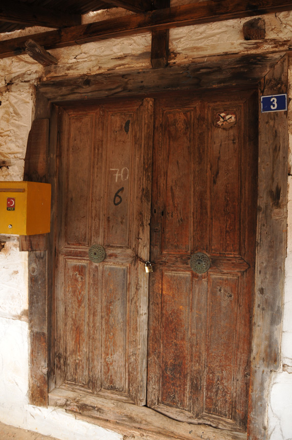
 We found a mountain village typical of the region, where we parked the vehicle and immediately set off. In the village we still see the ancient threshing floor, neatly lined with stones, which referred to life here in the high mountains in the past. Almost deserted today, this village also tends to decay more and more. There used to be magnificent and profitable wine growing up here, as an older villager tells us about his great-grandfather. The terraces laid out by industrious farmers are still clearly visible, although they have not been planted for decades.
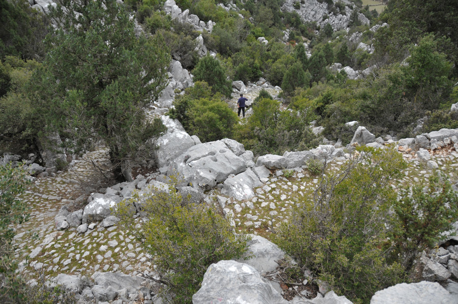
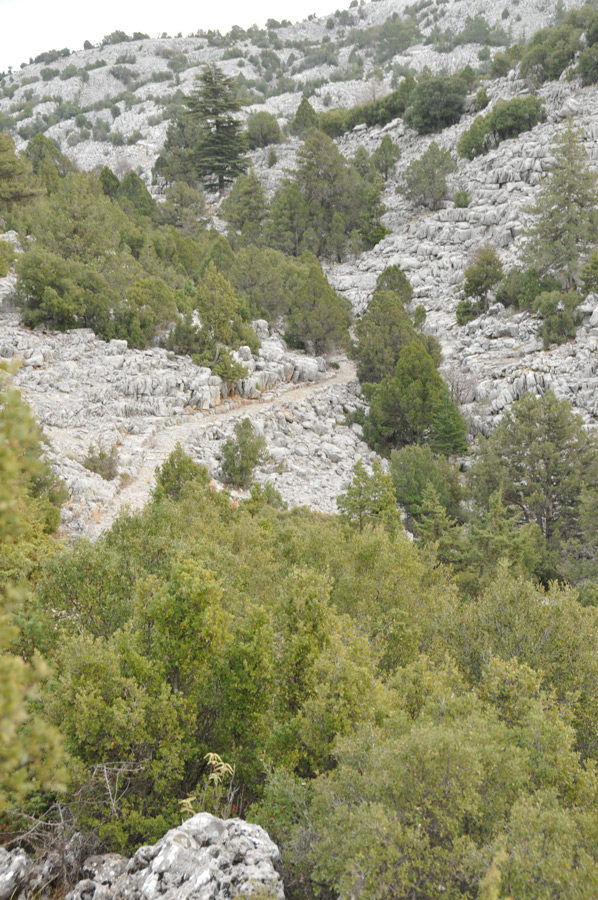
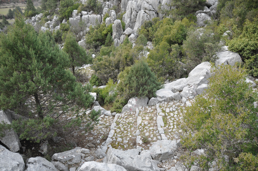
And all of a sudden it is in front of us, the trade route, about 1.5 meters wide, neatly paved with natural stones, neatly bordered with larger boulders on the sides and clearly laid out steps within walking distance of the camels. This path stretches for many kilometers through the mountains, sometimes over a high plateau, then along the mountain slopes with a magnificent view of the valleys.
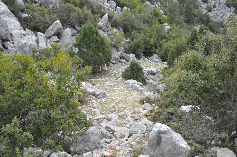 We are completely perplexed to come across such a facility here in the desert, which extends to a length of about 6.5 kilometers above Akseki. It is sometimes quite strenuous, because in the middle there are passages that are completely blocked by falling rocks that weigh almost a ton. Sometimes it looks like the huge boulders have been carefully placed on the path so as not to destroy the "road". We even find an alternative passage, which was probably created for encountering camel caravans. With their loads hanging to the right and left of the animals, the camels certainly filled the entire width of the street. So it's no wonder that alternatives were created in the narrow area in the valley.
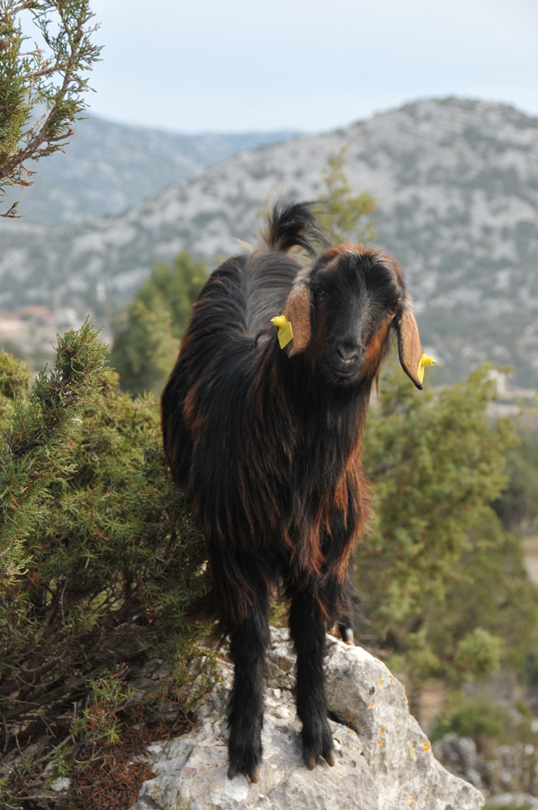
On a high plateau we come across two huge kangals who greet us barking loudly, they had probably noticed us long before. Only a little later we come across the mountain farmer's herd of goats. Powerful and formidable animals, these kangals capable of protecting the herd. Then there is absolute calm again.
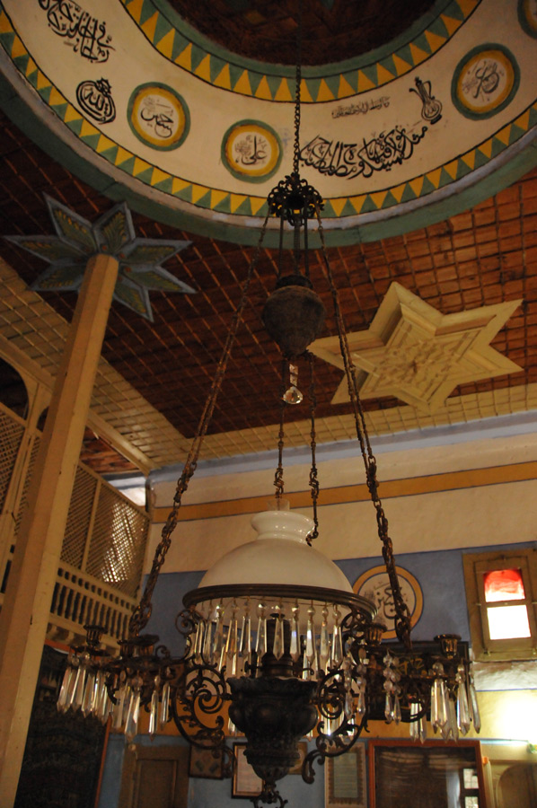
Fire engine stored in the mosque
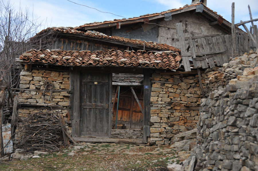
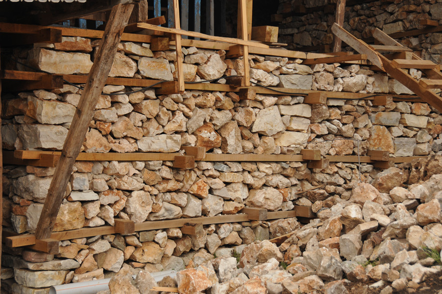
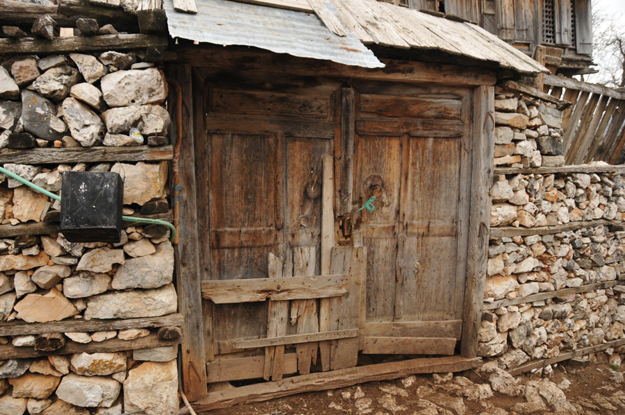
 In the middle of nowhere we find a village that was abandoned a hundred years ago and was once filled with life by a few hundred inhabitants. The terraced fields are still clearly visible. The houses, which are not completely dilapidated, show the typical construction of natural stone, which is simply layered loosely on top of each other. Approximately every 40 centimeters in height, a strong board is inserted inside and outside, which connects both boards to each other via notched connecting crosspieces. With the help of the boards, you could create a kind of layer system that was filled in the middle with leftover stone material. The timber took on the function of stabilizing the otherwise loose rock. A cost-effective one, since the building material could be taken directly from the surrounding area, but also a time-consuming and maintenance-requiring construction method. Some of the buildings were then plastered inside and out to ensure protection from rain and snow.
 Interestingly, we meet a small construction team in the middle of the village, which otherwise lies before us as if deserted. As is usual almost everywhere in Turkey, we are quickly invited here to eat and have tea, hospitality is still very popular. So Hoca, who is present and who is also active here in the function of the master builder, quickly joins the group. So it's no wonder that we quickly got into an interesting conversation. We learn that of the 800 inhabitants who lived in the village at the moment, 26 including the construction workers actually live in the village.
 An investor from Istanbul who once lived in this village has bought some of the old crumbling houses and will rebuild them in the original style. In this way, more life should return to the Yaila and, with life in an authentic environment, perhaps also the slow onset of hiking tourism.
The hoca also leads us to the small mosque in the center of town. We are mighty amazed to find an old fire engine in the next room, which still has the carrying wood and pump wood. In general, there are a few more details in the small mosque that the Hoca presents to us with obvious pride, including an ancient kerosene candlestick that can be adjusted in height using a chain hoist.
 Despite the sometimes strenuous march, we clearly enjoyed the total of 8 hours of hiking on the section of the caravan route in the Taurus in January. Certainly the snow that normally fell here at this time of year was missing, which would have given a different picture of the mountains. But we didn't miss him, quite the opposite.
If you are interested in one of the hikes described, please contact: This email address is being protected from spambots. You need JavaScript enabled to view it.
Please also read:
Laurel bushes line the path at Oymapinar Dam
Hiking - an alternative point of view
-
 Hiking from Akseki on Cervan Roads
Hiking from Akseki on Cervan Roads
Hiking from Akseki on Cervan Roads
-
Hiking from Akseki on Cervan Roads
Hiking from Akseki on Cervan Roads
-
Hiking from Akseki on Cervan Roads
Hiking from Akseki on Cervan Roads
-
Hiking from Akseki on Cervan Roads
Hiking from Akseki on Cervan Roads
-
Hiking from Akseki on Cervan Roads
Hiking from Akseki on Cervan Roads
-
Hiking from Akseki on Cervan Roads
Hiking from Akseki on Cervan Roads
-
Hiking from Akseki on Cervan Roads
Hiking from Akseki on Cervan Roads
-
Hiking from Akseki on Cervan Roads
Hiking from Akseki on Cervan Roads
-
Hiking from Akseki on Cervan Roads
Hiking from Akseki on Cervan Roads
-
Hiking from Akseki on Cervan Roads
Hiking from Akseki on Cervan Roads
-
Hiking from Akseki on Cervan Roads
Hiking from Akseki on Cervan Roads
-
Hiking from Akseki on Cervan Roads
Hiking from Akseki on Cervan Roads
-
Hiking from Akseki on Cervan Roads
Hiking from Akseki on Cervan Roads
-
Hiking from Akseki on Cervan Roads
Hiking from Akseki on Cervan Roads
-
Hiking from Akseki on Cervan Roads
Hiking from Akseki on Cervan Roads
-
Hiking from Akseki on Cervan Roads
Hiking from Akseki on Cervan Roads
-
Hiking from Akseki on Cervan Roads
Hiking from Akseki on Cervan Roads
-
Hiking from Akseki on Cervan Roads
Hiking from Akseki on Cervan Roads


https://www.alaturka.info/en/bicycle-travelling-e-bike-camping/6088-akseki-silk-road-invites-you-to-go-hiking#sigProId368f759049