")
")
")
Koblenz – The origin was the Castellum apud Confluentes
- Written by Portal Editor

The history of today's city of Koblenz was very changeable and is characterized by armed conflicts in numerous border conflicts and the associated major structural changes, also due to war damage.
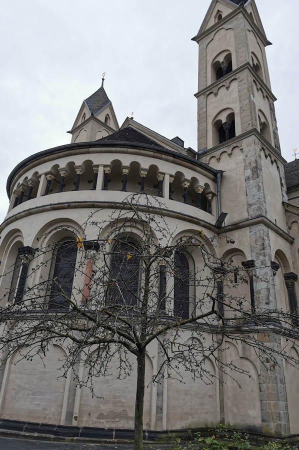
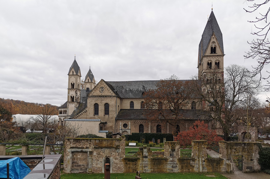
Koblenz area has been inhabited since the Stone Age. The Romans first built a fortified urban settlement here in the area where the Moselle and Rhine meet. The Confluentes fort was built in what is now the old town centre to secure the Roman Rhine Valley Road (Mainz-Cologne-Xanten) and in Niederberg the Niederberg fort to secure the Limes and the first bridges over the Rhine and Moselle. Koblenz is one of the oldest cities in Germany. After the retreat of the Roman troops in the 5th century, Koblenz was conquered by the Franks, who founded a royal court here. In the Castor Church, consecrated in 836, which we will come to later, negotiations between the three grandsons of Charlemagne took place in 842, which finally led to the division of the Frankish Empire in the Treaty of Verdun in 843. Castellum apud Confluentes (German "castle at the confluence") was the Latin name for the Roman settlement at the confluence of Moselle (Mosella) and Rhine (Rhenus), from which the German city of Koblenz developed.
A first fort was built at the time of Emperor Augustus
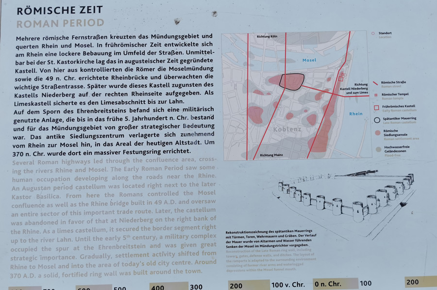 In the Gallic War against the Germans, Roman troops under Gaius Iulius Caesar reached the Rhine in 55 BC and built a first Rhine crossing between Koblenz and Andernach. In Koblenz itself, the remains of settlements near today's Mint Square, at the Kastor Church and at the Electoral Palace date back to the end of the first century BC. A first fort was built at the time of Emperor Augustus (27 BC-14 AD) at the confluence of the Moselle and Rhine to secure the Rhine-road Mainz-Cologne-Xanten. The first evidence of this Roman fort came in November 2008, when an ancient ditch was discovered at the Kastorkirche during construction work for the Federal Horticultural Show in 2011. The four meter wide and today still 2.5 meter deep ditch of a 100 × 100 meter large fort is the lacking evidence of the early Roman settlement of Koblenz, for which the area of the old town had previously been searched for 150 years in vain.
Roman bridges were built over the Rhine and Moselle. A 350 meter long pier bridge over the Rhine was built around 49 AD between today's Ehrenbreitstein and the Koblenz side of the Rhine. It consisted of approx. 650-750 oak trunks with iron tips, so-called pile shoes, of which 51 have been preserved to this day. The Moselle Bridge, located 50 m from today's Balduin Bridge, was built as part of the Roman Rhine Valley Road.
Fort Niederberg on the right bank of the Rhine
 At that time, the Treverer, who ruled the entire Moselle region, settled here. Since about 85 AD, the town belonged to the Roman province of Germania superior, which was established under Domitian around this time and was formed from the Upper German army district (exercitus Germanicus superior). In the late Flavian period, at the latest in early Trajanic times, i.e. shortly before or around the year 100 AD, the Niederberg fort for auxiliary troops was probably built under Emperor Domitian (81–96 AD) in Niederberg to protect the Roman Upper Germanic Limes. The Roman troops were thus moved from Koblenz to the right bank of the Rhine. The fort existed until around 259/260 AD, the area on the right bank of the Rhine was cleared by the Romans as a result of the devastating Frankish offensive.
Late Roman fort in the area of today's old town
 After the Limes was abandoned, under Emperor Constantine (306-337) a 5.8-hectare fortification was built in the area of today's Koblenz old town, the late antique Confluentes Fort. Located on the flood-free ridge on the southern bank of the Moselle, its former extent is still clearly visible today. The surrounding moat probably formed a former arm of the Moselle and its course is still traced today by the streets “An der Moselbrücke”, “Alten Graben”, “Am Plan”, “Entenpfuhl” and “Kornpfortstraße”.
In contrast to many other Roman fortifications, the Koblenz ring wall existed long after Roman times and was integrated into the medieval and modern cityscape. Its scheduled laying down did not take place until the 19th century.
City wall towers - Evidence has been provided
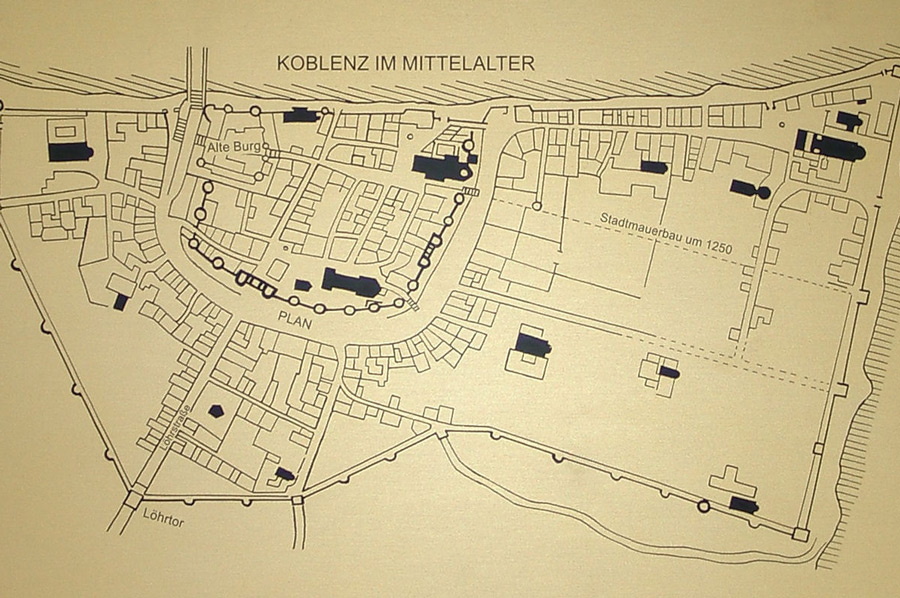 The wall was reinforced with a total of 19 round towers at a distance of about 30 meters on the west, south and east side, twelve of which are reliably proven by their preserved foundation remains. Of the four gates that can be assumed, only two have been proven, the southern one in today's "Marktstraße" and the eastern one in the area of the vicarage of the Liebfrauenkirche.
The towers were numbered from 1 to 19 by Adam Günther, starting on the northwest side. The foundations of the east tower of the old castle consist of the remains of a Roman round tower (tower 1). Extensive excavations on the Münzplatz were able to confirm the course of the Roman city wall on its westernmost side. However, there is no evidence of the intermediate towers 2 to 5 and the gate on the entire west side. Just the location of the south-west corner tower is documented again, as it is still entered in a cadastral map from 1812. The west side of the city fortifications is around 140 meters long.
Between corner tower 6 and the west gate tower of the south gate was another tower at a slight bend in the city wall, the stump of which served as a cesspool for sewage well into the 1870s. Just a few remains of the southern gate have been preserved and are accordingly well documented, but these are completely sufficient to reconstruct such a gate. Further eastwards, a section of the wall was found in various house foundations "Am Plan". Tower 8 was demolished in 1852 during the construction of the former house at Am Plan 7. Towers 9 to 12 and 16 to 19 have also been found. Tower 18 lies exactly under the apse of the Florinskirche and was uncovered during restoration work in 1929. The towers all except tower 1 had an outer diameter of around 10 metres. Wall thicknesses varied between 2 and 2.5 meters. The distances between the individual towers were between 24 and 35 meters, but most often 26 meters.
Koblenz conquered by the Franks and then founded a Frankish royal court
 During the collapse of the Western Roman Empire in the 5th century, Koblenz was conquered by the Franks and then a Frankish royal court was founded. When the Roman troops withdrew, the Rhine and Moselle bridges were destroyed. The Roman city wall survived until the early Middle Ages. To this day, the remains of the wall and the streets of Altengraben, Plan, Entenpfuhl and Kornpfortstraße in the old town of Koblenz bear witness to the late Roman fortifications.
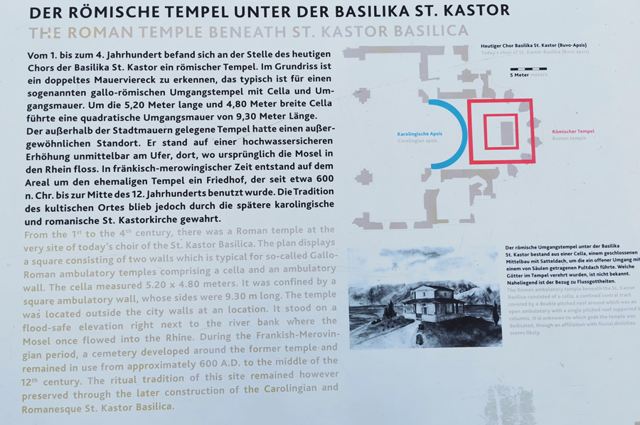
A temple complex for the Roman Mercurius and the Gallic/Celtic Rosmerta was built in what is now the city forest above Koblenz, not far from the Roman road. Roman coins found there show that the complex was used up until the 5th century. The remains of a Roman farm (Villa rustica) can be found on the Remsteck, which has been partially excavated and partially reconstructed.
The Rhine and Moselle bridges were probably destroyed when Roman troops withdrew in the 5th century. The Roman city wall survived until the early Middle Ages. To this day, remains of walls and streets in the old town of Koblenz bear witness to the late Roman fortifications.
Please read as well:
Dar Pomorza - three-masted sail training ship in Gdynia