")
")
")
Gazipaşa - Serene Paradise at the Sea
- Written by Portal Editor

Gazipaşa: Turkey, an ever-shining star in the global tourism market with returning tourists and foreigners deciding to settle by buying houses, continues to attract new tourists every year.
One of the favorite tourism centers of our country – where every part offers a different beauty and every scene is worth to be seen – is Antalya with Gazipaşa at one end. Gazipaşa, called “Serene Paradise”, is 180 km from Antalya city center. On the south of it, lies the Mediterranean with every shade of blue and on the north of it, rise the Toros Mountains displaying shades of green and offering its cool plateaus for local people on hot summer days.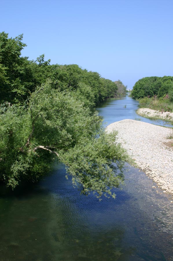 This beautiful district has a coastline of approximately 50 km and the center of Gazipaşa is located 3 km away from the sea. About half of the coastline of Gazipaşa, which has suitable beaches for swimming, is sand and the other part consists of rocks. The virgin sea inlets with a rare beauty hiding in these rocks are ideal places for swimming.
Land, plateaus or coastlines do not only display the beautiful and virgin nature of Gazipaşa; the sea is another remarkable source of beauty. Huge turtles (caretta caretta), which are becoming extinct and are under protection, and pretty Mediterranean sea calves (Monacus Monacus) are seen in Gazipaşa seashores. Gazipaşa beaches are one of the seashores of the Mediterranean, where Carettas come for breeding and their babies popping out from the eggs start their journeys towards to ocean. Special precautions are taken for the spawning and hatch periods of turtles by voluntary and official organizations.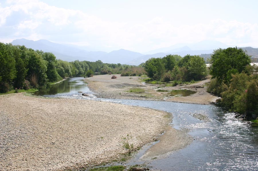 Ancient port nearby Selinus Beach extending 2.5 km and remainders of the castle protecting the port both show that this small special beach has an eternal history. Hacı Musa Stream flowing from the mountains reaches the sea from the eastern side of the beach after twisting on the plains. Both sides of the stream housing freshwater fish are decorated by dropping willows and other trees. When we look at the hillsides by raising our head, we can see the banana gardens, which love to overlook the sea and are intertwined with the ancient city’s artifacts scattered over a broad area.
Lamus Ancient City (Adanda): It is set up 15 km to the northeast of Gazipaşa District, 2 km to the north of Adanda Village and on the summit of a steep mountain.
Antiocheia Ad Cragum (Nohutyeri): It is in the Güney Village, which is 18 km away from Gazipaşa District.
Nephelis (Muzkent)
Mausoleums and Tombs in Hasdere Village
Halil Port and Iotape Ancient City
Altıkapı Han
Bıçkıcı Monastery
Cestrus – Hungarian Ruins
Silent Paradise Gazipaşa is waiting to be discovered by the tourism investors of the future with its virgin nature, yacht marina and airport.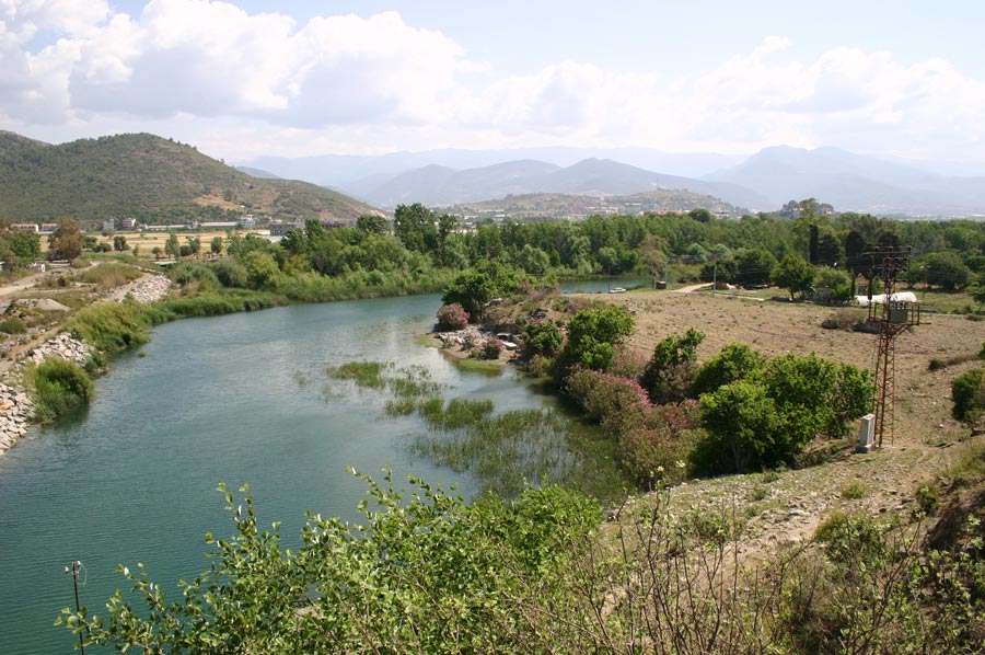 About 120 miles to the east of Antalya and about 30 miles east of Alanya you will find the small town of Gazipaşa which is slowly growing in size. At the moment about 44500 inhabitants are registered as living there. It is still not a very touristy place. Only about 500 foreigners live there. The actual centre of Gazipaşa is about 2 miles away from the coast.
The relatively flat area around Gazipaşa offers about 22 miles of agricultural land from east to west and is surrounded by the Taurus Mountains. The whole area of Gazipaşa is, up to now, an undeveloped area of Turkey and is almost untouched by tourism. Today there are just 4 hotels and one pension offering about 340 beds in total.
Because it has similar weather conditions to Alanya, Gazipaşa can also offer all the things tourists expect: sunny days at the beach and high air and water temperatures from April until November. There are two long, almost untouched beaches which offer extremely clean water.
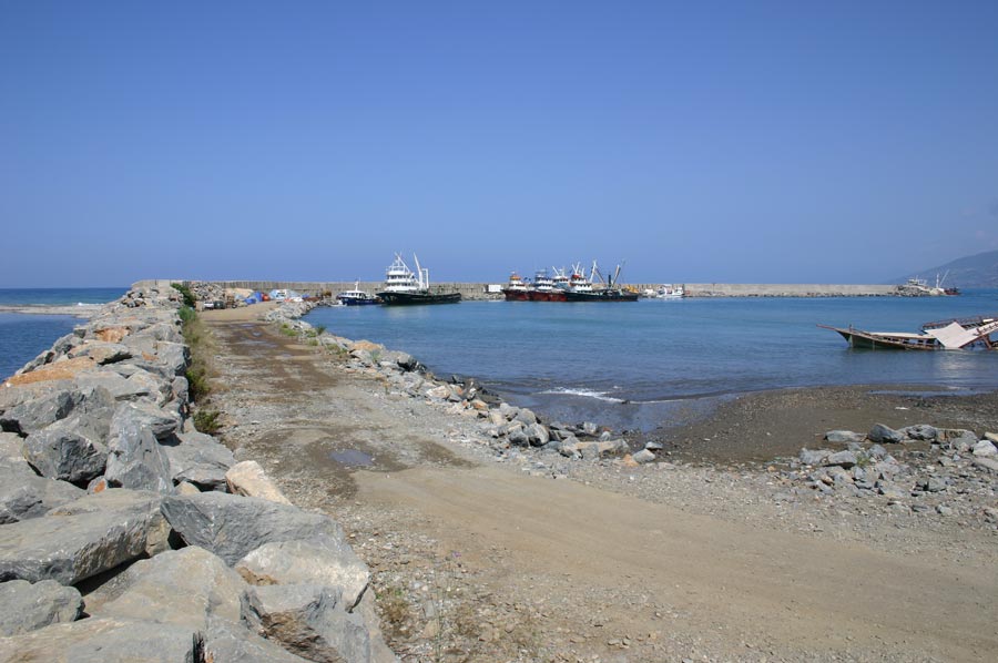
Around Gazipaşa you will find lots of historic ruins and wonderful mountain views. A small harbour is due to be finished shortly so there will be yachts in the future as well. Also being developed are a modern hospital, lots of different shops, companies offering all the necessary services and good road links to both the east and west.
An airport was built at Kahyalar about 8 years ago, but the runway is too short and there are many different political opinions about how it should be developed, so it is not open to international traffic yet. However, public discussions are again being held.
If the authorities can come up with a well thought-out plan for the future of all of Gazipaşa, there could be lots of advantages from increases in tourism provided they do not make the same mistake that they have made in lots of other places i.e. pushing the construction of big hotel complexes and forcing mass tourism.
New perspectives and views for the future need to be found to give the alternative choice of developing less crowded tourism and a changing outlook for people who want to move there. This chance is still available in Gazipaşa.
Geography, Climate and Flora of Gazipaşa
 Gazipaşa is a town in the Antalya province, which is one of the leading tourism centers of Turkey and tbe Mediterranean as well. The town is on the border between Mersin and Antalya, both of them important cities on the Mediterranean. Gazipaşa city center is 180 kilometers from Antalya. For the time being, the nearest airport to Gazipasa is in Antalya. However, there is a new airport under construction at Gazipasa which will be a hub for tourists arriving by air on their way to holiday resorts such as Alanya, Side and other famous tourism spots on the Anatolian coast. With the opening of the airport, tourism investment is expected to pick tip in Gazipaşa too. The westernmost town in the Mersin province is Anamur. The Kaladran stream marks the border between Anamur and Gazipaşa hence dividing the Antalya province from Mersin.
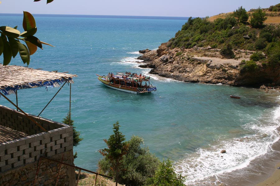 Gazipaşa sprawls over a plain that is 10 kilometers long and 7 kilometers wide. The plain carries the same name as the town. In its east extends the Mediterranean Sea. The Taurus Mountains rise in the north of the town, Gazipaşa has a coastline 50 kilometers long. Along this coastline there are three beaches: Pazarci, Koru and Selinus, 2 kilometers long each, and Yakacik (Kaledran) which is only 100 meters long. The rest of the coastline, that is 43,900 meters consist of rocks. However you can find very small rocky coves along the coastline and enjoy its privacy.
Nobody else will come while you are there. It is so small! The western section that follows the coast in the west of the Taurus Mountains in the north is called the Akcal Mountain range. The highest peak of this range is “Deliktas” which is 2,253 meters above the sea level. Lower lands consist of alluvial plains canning parallel to the coast that is flat lands formed by gravel, silt and clay deposited by waters coming down from the mountains. From the plain on the coast, the geography rises steeply into mountain heights. There are cliffs in front of the promontory on which the ruins of Selinus are located. On both sides of the elevated promontory extending into the sea there are beaches. The sand on these beaches is very fine, formed of silica particles. Cliffs are mostly formed of limestone. Sometimes they rise as high as 50 to l00 meters from the sea level. The earth near the sea is in dark chestnut color. It is suitable for vegetable, citrus and banana cultivation. As you move inland, the earth changes color and becomes red, which the agriculturists call terrarossa. It is more convenient for grain cultivation. In the mountains animal husbandry is the most frequent economic activity.
Climate of Gazipaşa
Gazipaşa displays the typical features of the Mediterranean climate on shores of which it is located. This pattern is characterized by dry and hot summers, warm and rainy winters. The amount of rain falling only in January and February equals that of Rize on the Black Sea coast, a record breaker in Turkey in terms of precipitation. But once the summer months arrive, there is almost no rain in Gazipaşa for five months. Rain, which begins falling at the end of autumn, continues until April and May.
Flora
Maquis, the thick, scrubby underbrush so typical of the Mediterranean flora is also seen in Gazipaşa up to 800 to 1000 meters altitude on the slopes of mountains overlooking the sea. They turn green with the rain during the winter and spring months. But when the summer heat settles in, they cannot grow much stay as squat trees. At the same altitude that is from 800 to 1,200 meters you can see pine forests intermingling with the bushes. Higher up, Austrian pines, cedars, spruce trees and junipers cover the slopes of the mountains as far as the upper border of the forest. The variety of flora changes according to altitude, the soil structure and other climactic and geographical conditions on the mountains.
Rivers around Gazipaşa
The Gazipaşa plain owes its productive characteristics to the rivers and streams coming down from the mountains. Alluvial earth coming down with their waters has been deposited on the flat ground providing the farmers with a highly productive soil. The valleys where Gazipaşa’s streams and rivers flow are deep and narrow. Where the inclination gets softer, the residue of gravel, silt and sand is quite deep. The rivers and streams of Gazipaşa are numerous. They are Sedre Stream, Delice Stream, Bickici Stream, Gokceler Stream, Inceagri Stream, Kucuklu Stream and the most famous Haci Musa Stream where migrating birds stopover at the point where it flows into the Mediterranean.
Please read as well: