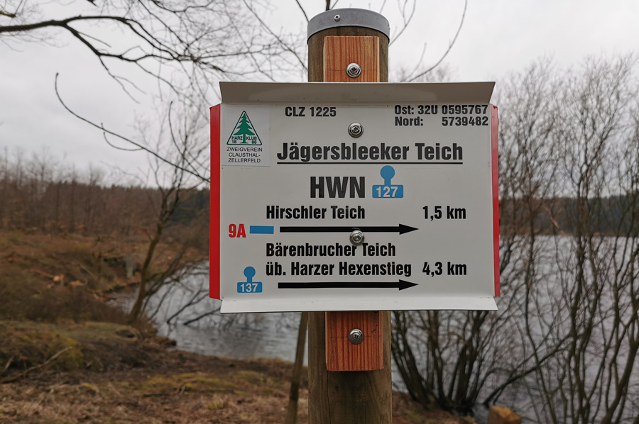
Hiking trail "Huttaler Wider Waage" - stamps 127 & 128
- Written by Portal Editor

As already reported in our article on the Harzer hiking needles, we had found increasing interest in the targeted hike to the multi-layered stamping points to the special highlights of the Harz hiking trails and thus also decided to equip ourselves with hiking passes and to supplement them with the various stamps.
We'll see how far we can get with that.
 At the same time, we would like to encourage you to do the same, so we will present some of these highlights in no particular order.
The possibility of using e-bikes is also important for us, because we would like to keep our main location on the Prahljust campsite, use cars as little as possible or replace them with e-bikes. With an area of at least 2,226 km2, the distances to the individual stamping points in the Harz Mountains would sometimes be too far to hike. So we will first explore the stamping points in the vicinity, later we will use the e-bikes to approach the selected hiking routes and then start the hike. Only in late spring do we plan to include the stamping points for multi-day tours. The still completely snow-covered "Ackerweg" from the Hanskuehnenburg back to Clausthal-Zellerfeld in mid-March was too much "surprising".
From the Prahljust campsite to the "Huttaler Wider Waage"
 The "Hutthaler Wider Waage" water hiking trail is a 6-kilometre circular route that takes you past water management structures that were once particularly important for mining in the Upper Harz. For us, the starting and end point of this themed circular hiking trail is the Prahljust campsite south-east of Clausthal-Zellerfeld.
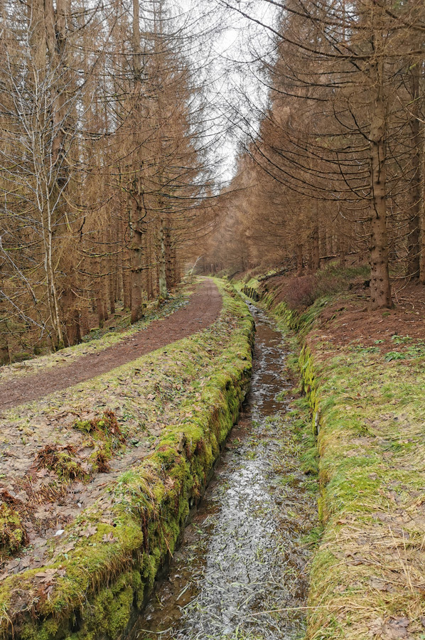
Almost immediately next to the entrance road to the Prahljust campsite is the forest path with a car park in the direction of Huttaler Wider Waage, which initially climbs slightly and then turns left, slightly inconspicuous, into a narrower path. From here it goes downhill to the pond or water basin, or as they say locally: to the counterweight. Since some paths fork at the parking lot, please choose the path to the Huttaler Wider Waage.
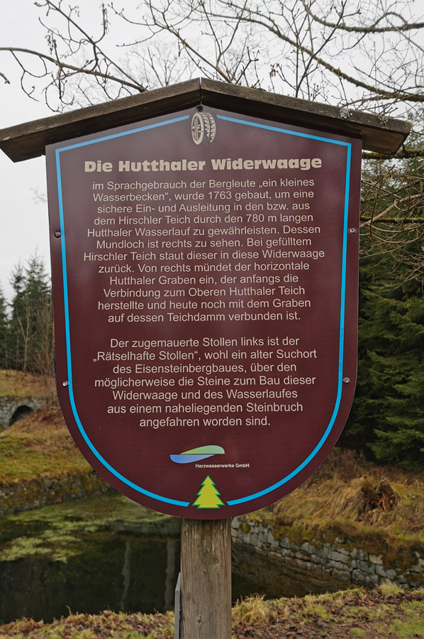
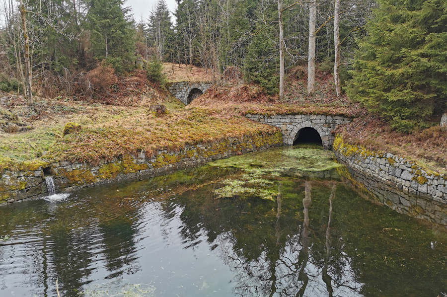
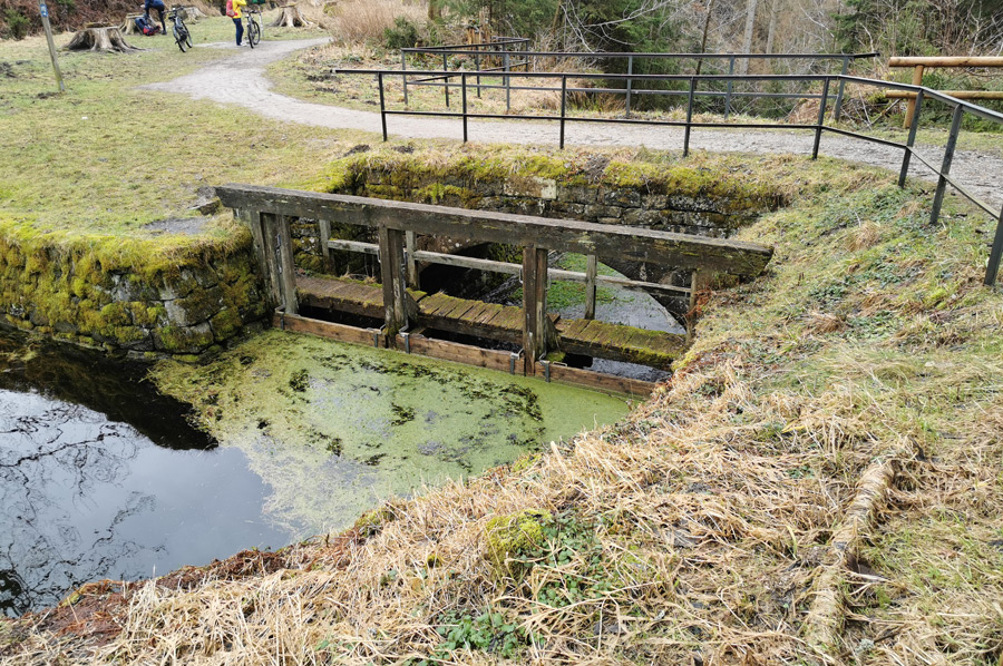
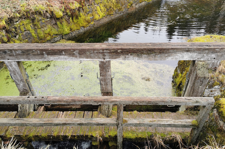 As can be seen from the pictures, the water is dammed up here by a wooden weir structure, a so-called failure. This pond is connected to the Hirschler pond on the other side of the ridge by the so-called Huttal watercourse and communicates with it. From the Huttaler Graben, water from the Schwarzenberg and from the Polsterberger Hubhaus is fed to the Wider Waage. If the weir is dammed up, the water is passed on through the Huttal watercourse to the Hirschler pond. In the past, it could be used there to supply power to the very productive Caroline and Dorothea pits. Here is the stamp office 127 of the Harzer hiking needles.
Also flood protection for the Clausthal district
 At high tide, the weir panels can be removed. Then the flow gradient reverses and water from the Hirschler pond flows through the Huttaler Wasserlauf and through the Huttaler Wider Waage into the Huttal and then further in the direction of Söse. As a result, the flood situation in Clausthal was decisively defused.
The Huttaler Wider Waage was created because the two most profitable and highest mines, Dorothea and Carolina, needed more water for the sweeping and artificial wheels for ore extraction and water lifting.
 With the construction of the Wider Waage in the years 1763 to 1776 and the extension of the catchment area until about 1860, it was possible to draw water from the Söse area via the Kautztaler Graben, the Alten Polsterberger Wasserlauf, the Schwarzenberger Graben and the Grüneberger Graben, via the Huttaler Wasserlauf, fed to the Hirschler pond. Due to the larger water supply, the two turning wheels of the shafts could now be built in their immediate vicinity.
The Huttal watercourse was already dredged in 1767. At first it had a bottom gradient to the Hirschler pond and could only lead the water in one direction, namely to the Hirschler pond.
 Around 1850, the need to improve flood protection for the mountain town of Clausthal was seen, and the Huttal watercourse was rebuilt so that large quantities of water could be diverted in the opposite direction from the Hirschler pond to the Söse area. For this purpose, the tunnel cross-section was widened considerably to a width of around 2.0 m, and hydraulically disruptive curves were straightened out. The gradient was reversed. To do this, the watercourse in the Huttal area had to be deepened by around 1.0 m. Today's relatively elaborately designed building also dates from this period.
The Polsterberger Hubkunst and Dr.-Martin-Schmidt
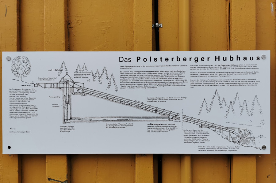
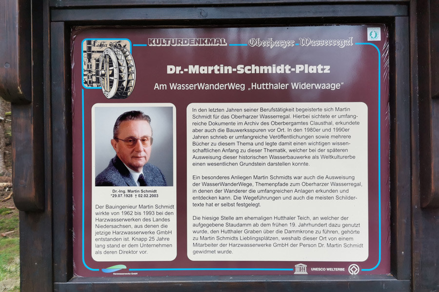 After a few photos on site, we continue the path and after a few kilometres we reach Dr.-Martin-Schmidt-Platz, idyllically situated with a bench for snacks, where you can take a break. A sign informing you about the activities of Doctor Martin Schmidt explicitly points this out. If this is too spartan for you or if you forgot your lunch, please continue on the path and you will reach the Polsterberger Hubhaus a little later. In 1801 Polsterberger Hubkunst was created. Thanks to the art of lifting, water could be pumped from the Dammgraben into the Huttaler Wider Waage system and flow into the Hirschler pond.
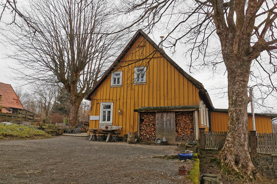 Here there is also the possibility of a stop combined with the enjoyment of some Harz specialties. However, it is important to note the opening hours when planning.
We continue on our way and a little later we reach the refuge "August Weppner Hütte", also idyllically situated at a reservoir and equipped with the stamping point 128. A little later we have reached the Hirschler pond, which we have already mentioned several times, from where we start our way back to the Prahljust campsite.
 A magnificent day tour with great learning effects and the realization that the Harz water shelf means something really extraordinary in architecture for the mining industry and the residents and is therefore rightly a World Heritage Site.
We look forward to more insights along the way.
Please read as well: