")
")
")
Sinkholes - Red and Blue Lake next to Imotski
- Written by Portal Editor

Sinkholes - As an extremely interesting day trip destination Željka from Camp Galep had recommended a tour to the sinkholes at Imotski, probably among the most impressive, geological natural sites in the world.
We know the cardinality of sinkholes from Turkey, just to mention the two huge caves Cennet and Cehennem (heaven and hell) near Narlikuyu. Unlike the Turkish caves, the two sinkholes of Imotski just before the border with Bosnia and Herzegovina are, however, filled with a lake, in its depth depending on the season. We were curious what to expect.
Sinkholes - Directions to Imotski along the Cetina River Valley
 Of course, the planned tour lead us again into previously uncharted territory, who knows what else is there to discover. And it was, we will report later. So we planned the journey for Imotski along the river valley of Cetina, on which we wanted to take a rafting trip later. After about 8 kilometers along the Cetina our GPS finally gave up forcing us to turn back, the valley had become noticeably tighter and culminated in serpentines, we had to go over the mountains, the route should better just be used by car.
A little later we were at an imposing bridge structure that crosses towards the Cetina River to Podgrade. Some residents in the context speak of this bridge of a Roman construction, which may have once been true, perhaps is true today when talking about the foundations. In its present form it has been built by Austrian engineers of Emperor Franz Joseph's time. Now, after some photos being taken, as well from the beautiful landscape of river Cetina, we directly continue to the Imotski Blue Lake (Modro jezero or Plavo jezero).
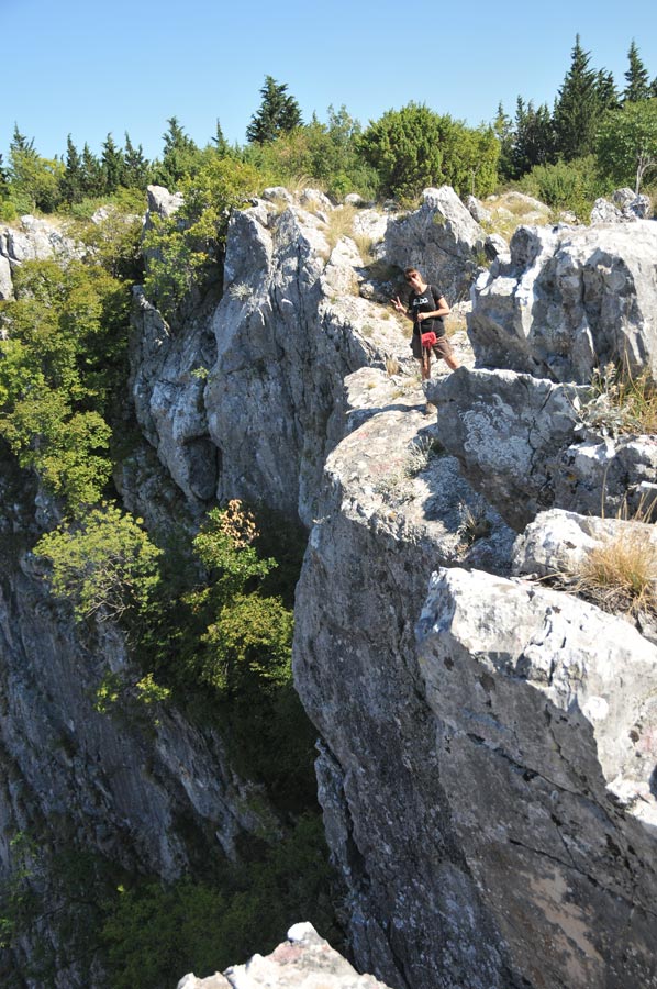
The diameter of the sinkhole is about 600 meters
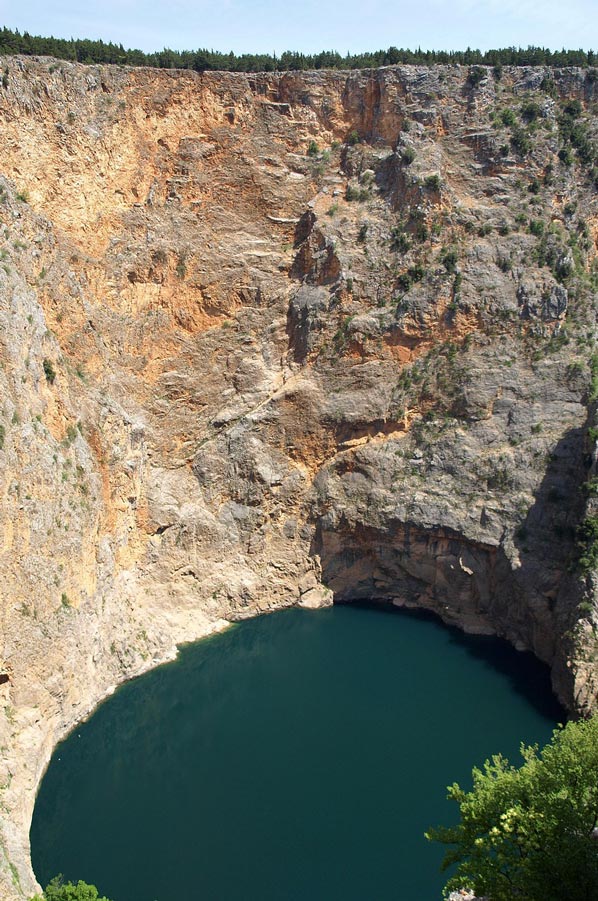
 It was probably to be attributed to the expected rain for a long time, which remained our first view of the lake somewhat disappointing, so little water at the bottom of the sinkhole, moreover, was not true blue. Well, impressive deep down we went anyway and how we should get to know a little later, is the bottom of the lake to be seen, because the water is completely vanished, traditionally it is used as a football pitch for a game. Of course, it is easy to see that the height of the water level considerably varies depending on rainfall. Well filled, which is the case usually in the spring, the lake has a depth of about 100 meters. The diameter of the sinkhole is approximately 600 meters. The cliffs rise between 400 and 900 meters almost vertically into the air.
At the top of the sinkhole are the ruins of the castle Topana, which was already mentioned in the 10th century in a Byzantine writing. It is the real origin of the town Imotski which propagates at the foot of the castle and on the verge of collapse funnel. The city center is just a short walk from the lake. On a paved road, which was laid out on a visit of Emperor Franz Joseph, you can easily walk down to the lake.
Sinkholes - For the hikers among our readers:
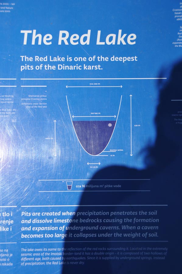
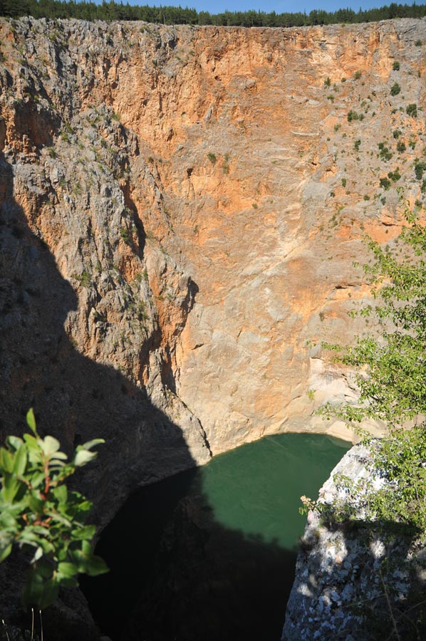
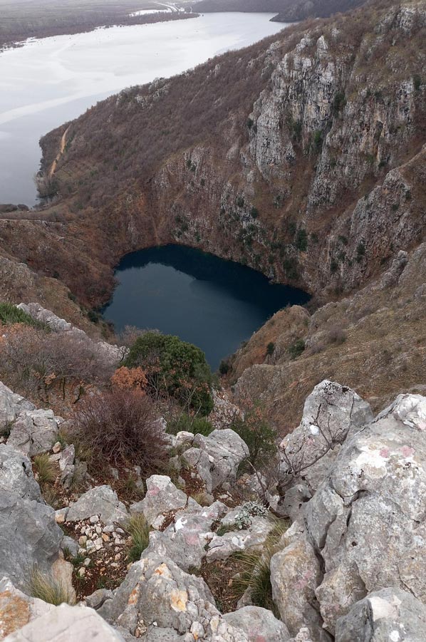
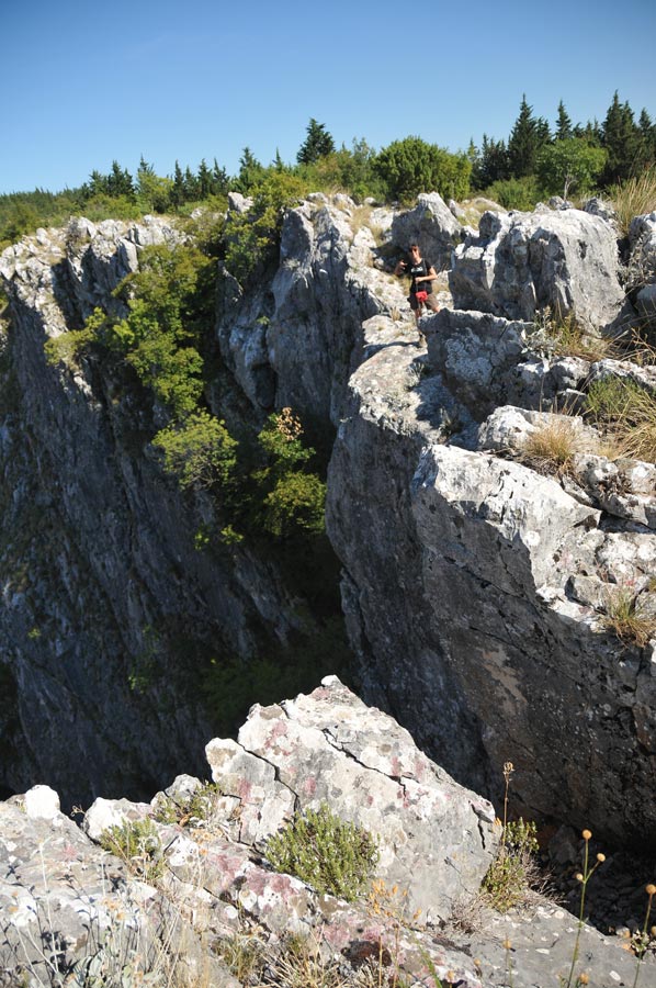
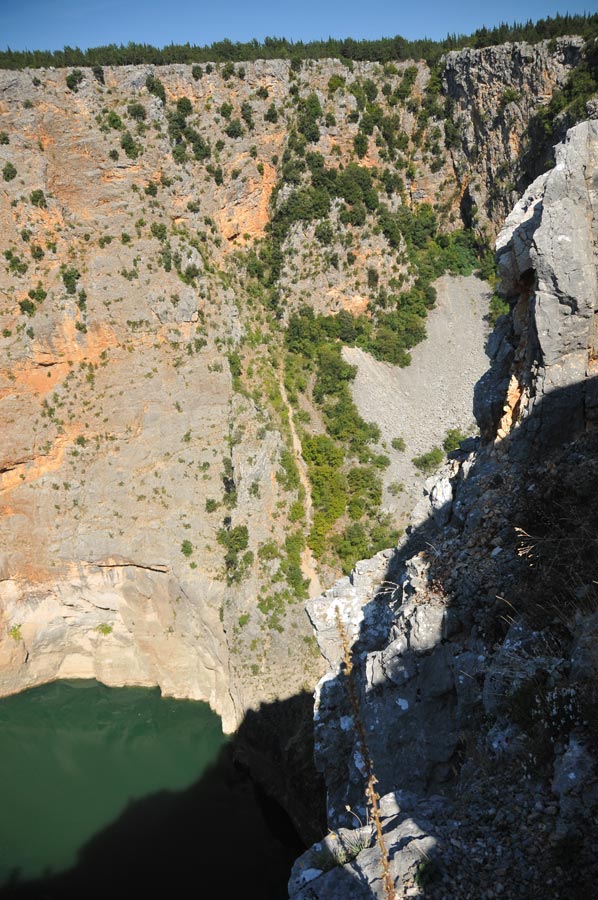 About one kilometer north-west of the Blue Lake the Red Sea (Croatian Crveno jezero) is located, which is considered one of the largest water-filled sinkholes in the world. Again, initially a bit of a disappointment, because the Red Lake gleamed rather green. The lake is named after the reddish color of the rock wall, reaching up to 250 meters vertically above the water surface. The water itself is rather deep blue.
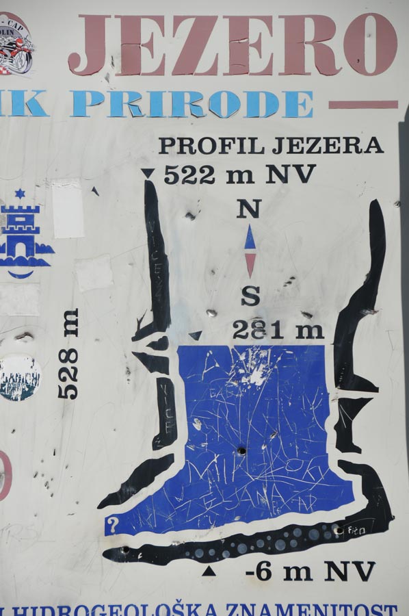
The nearly circular lake has a diameter of about 200 meters on the surface. Its depth is around 287 meters, where the water level may vary seasonally by 30 to even 50 meters. Its age is estimated at two million years.
A diving expedition discovered an entrance to a branched cave system with air-filled cavities in 15 meters deep in the summer of 1998, which has a second input in the rock face above the water level and leads to another, though much smaller lake. In 170 meters depth by means of a diving robot, a large inflow into the lake was detected.
For the walkers among our readers: there is a well-marked footpath around the doline of the Red Sea, beautiful views of the sinkhole and the valley of Imotski will open from the path.
Sinkholes – The Red and Blue Lakes near Imotski
Croatia is known for its stunning coastlines, but the interior also boasts spectacular natural phenomena. One of the most impressive geological wonders are the two sinkholes of Imotski: the Blue Lake (Modro Jezero) and the Red Lake (Crveno Jezero). These fascinating natural phenomena are not only of scientific interest but also popular destinations for adventurers and nature lovers.
Imotski – A Town of Geological Wonders - more details
Location and Geographical Features
 Imotski is located in the hinterland of Dalmatia, near the border with Bosnia and Herzegovina. The town is situated on a karst plateau that has been shaped by tectonic movements and erosion over millennia.
Historical Significance of the Region
Imotski was already settled in ancient times and was a strategically important point for various empires for a long time. The medieval Topana Fortress towers over the city and offers breathtaking views of the Blue Lake.
The Blue Lake – A Natural Wonder with Changing Water Levels
Formation and Geological Features
The Blue Lake is a huge karst sinkhole created by the collapse of a cave ceiling. The lake's depth varies seasonally – in summer, it can even dry out completely, while in spring, it rises significantly due to meltwater.
The Legend of the Blue Lake
According to an ancient legend, a city once stood on this site, which was struck by a curse. The water now covers the remains of the sunken city.
Activities and Sights
• Swimming: When the water level is high enough, you can swim in the Blue Lake.
• Hiking: A circular trail leads around the crater rim and offers spectacular views.
• Soccer in the Dry Lake: A local tradition is to play a soccer game on the dry lake bed.
The Red Lake – Europe's deepest sinkhole
Why is the water so red?
 The Red Lake owes its name to the reddish rock walls that surround it. The water itself is deep blue, but the reflections from the rocks make it appear reddish.
Geological Facts and Features of Sinkholes
• With a depth of over 280 meters, the Red Lake is the deepest karst sinkhole in Europe.
• The walls are almost vertical, making access to the lake extremely difficult.
• The lake has underground connections to other water sources, which keeps its water level constant.
Can you visit the Red Lake?
Yes, but only from above. There are no official paths leading to the water, and walking on the steep slopes is dangerous.
Legends and Myths Surrounding the Lakes
Stories of Sunken Cities
 In addition to the legend of the Blue Lake, there are also stories that the Red Lake once swallowed a city because its inhabitants were arrogant and disrespectful.
The Curse of the Red Lake
A myth says that anyone who throws a stone into the Red Lake will experience bad luck. Nevertheless, it is a popular test of courage for tourists.
The Scientific Importance of Sinkholes
Why are they so unique?
These sinkholes are a prime example of karst geology and help scientists better understand the development of such formations.
Research Projects and Geological Studies
There are regular diving expeditions to explore the depths of the Red Lake and analyze underground water connections.
Recreational opportunities and outdoor activities
Hiking and exploration tours
 There are numerous hiking trails around the lakes, offering spectacular panoramas.
Swimming in the Blue Lake
In summer, when there is enough water, you can swim in the Blue Lake – an unforgettable experience.
Climbing and Adventures around the Lakes
For adrenaline junkies, there are climbing routes and canyoning tours in the area.
Best Time to Visit and Useful Tips
When to Visit Imotski?
- Spring and Autumn: Pleasant temperatures for hiking
- Summer: Perfect for swimming in the Blue Lake
- Winter: Dramatic landscape with often frozen water
Safety Instructions for Visitors
- Do not climb into the Red Lake! The steep walls are dangerous.
- Wear hiking boots – the trails are often rocky and slippery.
- Bring enough water – there are few supply points.
Conclusion on the topic of sinkholes
 The Blue and Red Lakes near Imotski are geological wonders that captivate every visitor. Whether hiking, swimming, or simply marveling, the natural beauty of these sinkholes makes them a must-see for travelers to Croatia.
Frequently Asked Questions (FAQs)
1. Can you swim in the Red Lake?
No, the lake is difficult to access and not suitable for swimmers.
2. Is the Blue Lake always full of water?
No, it can dry out in summer.
3. Are there guided tours to the lakes?
Yes, local operators organize hikes and excursions.
4. How deep is the Blue Lake?
Between 0 and 90 meters, depending on the season.
5. Is visiting the lakes free?
Yes, there is no entrance fee.
Coordinates: 43 ° 27 '15 "N, 17 ° 11' 57" O and 43 ° 27 '1 "N, 17 ° 12' 38" O
-
 Cetina Bridge
Cetina Bridge
Cetina Bridge
-
Cetina River
Cetina River
-
Sinkholes in Imotski
Sinkholes in Imotski
-
View to Imotski
View to Imotski
-
Sinkholes in Imotski
Sinkholes in Imotski
-
Sinkholes in Imotski
Sinkholes in Imotski
-
Sinkholes in Imotski
Sinkholes in Imotski
-
Ruins of Castle Imotski
Ruins of Castle Imotski
-
Sinkholes in Imotski
Sinkholes in Imotski
-
Sinkholes in Imotski
Sinkholes in Imotski
-
Sinkholes in Imotski
Sinkholes in Imotski
-
Sinkholes in Imotski
Sinkholes in Imotski
-
Sinkholes in Imotski
Sinkholes in Imotski
-
Sinkholes in Imotski
Sinkholes in Imotski
-
Sinkholes in Imotski
Sinkholes in Imotski


https://www.alaturka.info/en/croatia/imotski/2977-sinkholes-red-and-blue-lake-next-to-imotski#sigProId007a5c8b39
Please read as well: