")
")
")
Diking and land acquisition - Harlebucht became marshland
- Written by Portal Editor

Harle Bay was originally a bay about 15 kilometres wide and about 10 kilometres inland, into which the Harle River of the same name drained.
Located a little north of Wittmund in today's Friesland and East Friesland, the water ingress of the second Marcellus flood in 1362 caused secondary bays to form in the hinterland to the Geest near Jever and thus enlarged the Harlebucht enormously.
Natural drainage without sluices and dikes
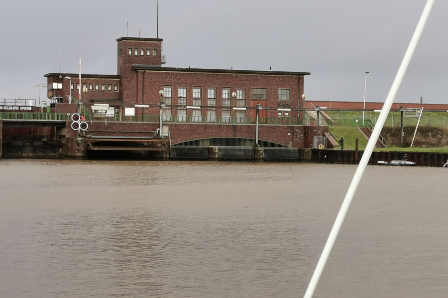 Near the Will district of Wittmund, the two source branches Norder Tief and Süder Tief flow together to form the so-called Harle. Both are bodies of water that originate in moorland. The Harle runs east past the core town of Wittmund and then meanders northwards. It crosses the district of Carolinensiel and today flows through a lock and a pumping station into Harlesieler Hafen and from there into the North Sea. In the Middle Ages, the Harle flowed into the Harlebucht near Altfunnixsiel, which was gradually diked from 1500 onwards. The estuary of the Harle is the Carolinensieler Balje. It is one of the southern arms of the Harle creek that separates the North Sea islands of Spiekeroog and Wangerooge.
Harle Bay in the Middle Ages
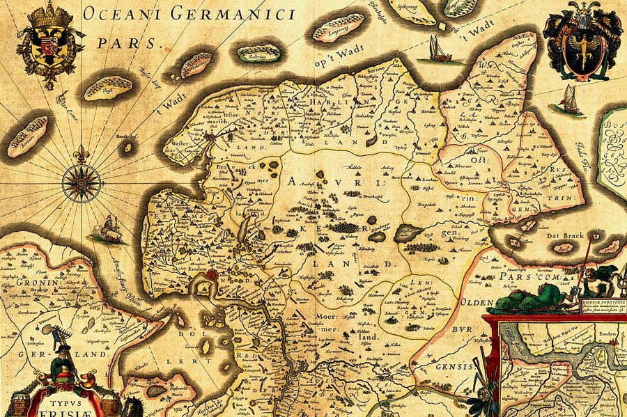 The bay extended in the west from Neuharlingersiel to Minsen at a width of about 15 kilometres. Inland, it stretched about 10 kilometres to Berdum. The area of the former seabed is still clearly visible on satellite photos. Around 1550 the diking of the water areas for land reclamation began. Little by little, fertile marshland was gained until the Elisabethgroden was completed in 1894.
The Golden Line, created in the 17th century as the border between the Principality of East Friesland and the County of Oldenburg, ran right through the former bay. The reason for their determination was to avoid disputes over ownership and the drainage of the newly acquired land.
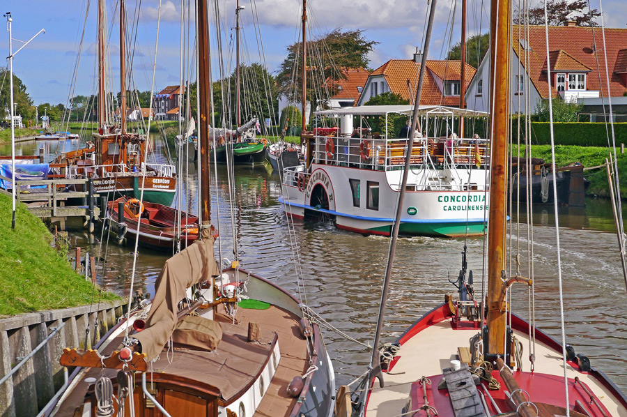
At its peak in the 18th and 19th centuries, it was the second largest East Frisian sluice and trading port. Today, with the traditional flat-bottomed sailing ships anchored here and the historical building ensemble of the German Sielhafen Museum, it is a place with a special charm and maritime flair.
Land reclamation through embankments
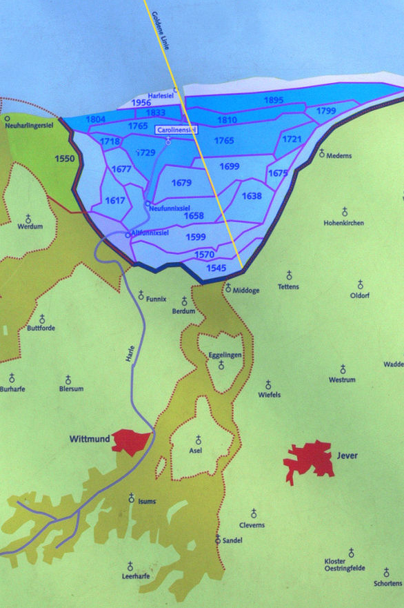 The coastline before the land reclamation is marked from west to east by the Werdum Altendeich and the old dyke foreland Werdum Altengroden, Altfunnixsiel an der Harle, the Berdumer Altendeich, Altgarmssiel am Tettenser Tief, as well as Medernser Altendeich and Mederns in Wangerland. The advancing of the dikes and sluices can be seen in numerous other street and place names.
Around 1500, systematic land reclamation through embankments began.
Diking describes a process of land reclamation. To this end, dykes are being built in front of the mainland and the surface water flowing off the dyked area is channeled into the sea through ditches and sluices. The diked land is called Koog in Schleswig-Holstein, Groden in Lower Saxony and Polder in the Netherlands and on the Ems. In just a few years, the previous salt marsh will turn into a pasture. Piece by piece, new, fertile marshland was reclaimed from the North Sea and settled, a huge marshland characterized by large farms.
Explorations by bike
 The project: "Experiencing the Harlebucht" (in both senses of the word: traveling by bike and learning something at the same time) began in 1994 by the museum educator of the Alexander von Humboldt School Wittmund for the Sielhafenmuseum Wittmund-Carolinensiel. It was taken up by the regional environmental centre RUZ in Schortens and came to a temporary end with the creation of eight cycle tours in the Harlebucht.
Round tour "Land gain in big steps" in Wittmund. To go biking. ...
Distant princes. To go biking. ...
Jan-Schüpp bike path. medium cycling. ...
Round tour "Warften and Wurten" in Wittmund. To go biking. ...
Golden line tour. To go biking. ...
Wangerland Tour. ...
Handbike circular tour Harlesiel - Bensersiel - Esens (barrier-free)
(reports on the bike routes will follow this spring)
In terms of tourism, the Harle is important for paddling and in the ports of Carolinensiel and Harlesiel for boat and ferry traffic. Harlesiel is the ferry port to the island of Wangerooge.
The Harle lies below Neufunnixsiel in the FFH area "pond bat habitats in the Wilhelmshaven area" and in the "pond bat water bodies" conservation area.
Please read as well:
Neuharlingersiel - a colourful fishing port in the storm
Geiseltalsee - hundreds of years of coal mining - today tourism