")
")
")
Schenkenschanz – by chance due to a purchase
- Written by Portal Editor

Despite many experiences in life, there is always something new, previously unknown, that you come across. Or have you ever heard of Schenkenschanz or even visited it?
Neither did we, until we bought a car trailer, which said Kleve in its pick-up address, but ultimately led to Schenkenschanz. You never stop learning, especially since we are always interested in history. So we were already surprised when we arrived to come across a kind of "castle wall" on a dike between the Rhine and probably former side arms, which today, however, serves more to protect against flooding.
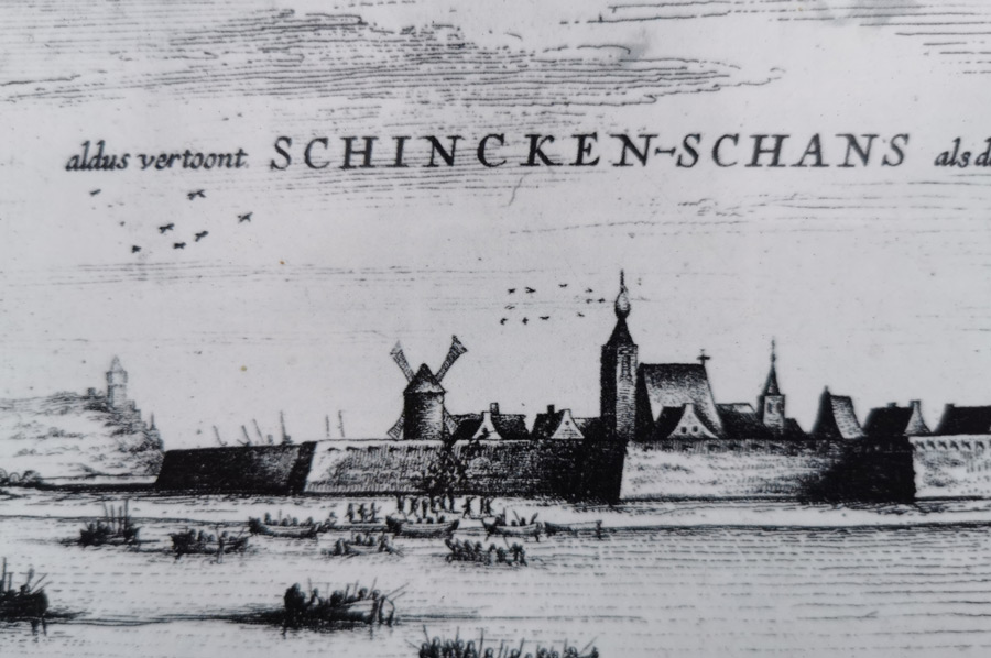
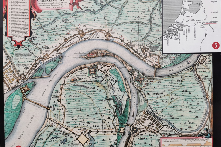
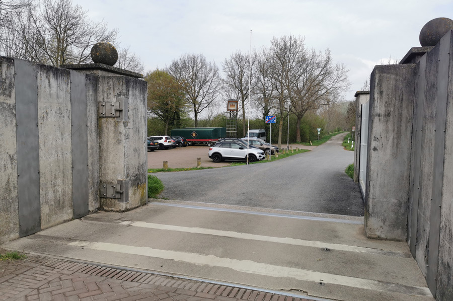 Right and extremely important, because the area around Schenkenschanz was in its entire history in the sphere of influence of the Rhine current with frequent floods, severe bank failures, island formations and shifting of the river bed and also served as a control and customs station on the Rhine in the dim past, but more on that later. The place itself is closed to car traffic, which doesn't mean there's no parking outside, in short, it's just too small and cramped. There are huge flood gates that can be closed at high tide. Some explanations can also be seen on boards at the entrance to the village, which refer to the floods or the history. The drawing by the cartographer Johann Bucker shows that the place with the former fortifications was still located in 1713 at the fork of the Waal and Nederrijn. There are also some former islands and sands (e.g. Fridericks Wardt and Salmorth). Today Salmorth is the foreland to the villages of Griethausen, Brienen and Düffelward. After hydraulic engineering measures in the 18th century, the river no longer divides at Schenkenschanz, but only further north on Dutch territory into the Waal and Nederrijn arms.
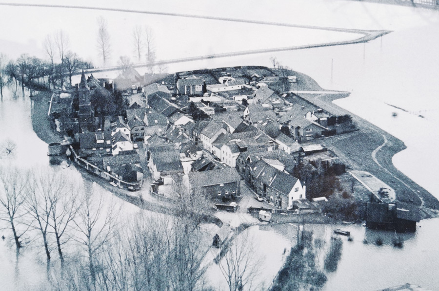 In the past, Schenkenschanz was regularly surrounded by the spring floods of the Rhine, as the photograph shows. Today there are only sporadic storm floods, so that the place can be reached by land via the Altrheinbrücke in Kleve-Griethausen. Today, this is the lowest point on the access route to the subsequent, a good four-kilometer-long dike road.
The earlier ferry connection across the Griethausener Altrhein to Düffelward was discontinued by the city of Kleve after 111 years. Since May 16, 2020 there has been a ferry connection again during the summer months on weekends and public holidays. However, there is only a small ferry boat for pedestrians and cyclists.
Hard to believe - Dutch and Spain in dispute over Schenkenschanz
 The town owes its existence to the Eighty Years' War between the Netherlands and Spain. In 1579, seven Dutch provinces formed the Union of Utrecht against Spain. They refused to obey the Spaniards. They also made pacts with England: Queen Elizabeth I supported them with money and soldiers through Robert Dudley.
The lord had a fortress built by Field Captain Martin Schenk von Nideggen in 1586/87 in what was then the fork in the Rhine and Waal, on a large, marshy and strategically important headland called "'s Grevenward", "Saarbrugg" or "Fuchsenloch". At the end of the 16th century, the fortress was even one of the strongest in Europe. It was of great importance and long considered impregnable as a gateway to the Netherlands.
 The strategic importance becomes clearer when considering the topographical situation at the time: the splitting of the Rhine into a southern Waal and a northern estuary, the Nederrijn (more precisely: Pannerdens Canal), is happening today about 7.5 km west (downstream) of Schenkenschanz Millingen on the Rhine. Before the Schenkenschanz fortress was built, however, this was about 5 km further upstream, at about the level of today's Griethausen. The old Rhine there is still a reminder of this today as the remnant of the former course of the river.
Thus, the land on which Schenkenschanz was built formed an upstream headland, which was also called Spyck. Even today there is Spyck as a field name north of Griethausen, here is an industrial oil mill. By shifting the river courses below Schenkenschanz, the fortress became an island from which both river courses could be controlled. Schenkenschanz had the nickname guardian of both streams.
 During the Spanish-Dutch War, for example, the town was the scene of constant military conflicts and was repeatedly bombed, set on fire and looted. In July 1635, Spanish troops were able to conquer the fortress and hold it briefly. Elector Friedrich Wilhelm von Brandenburg was present during the preparations for the Dutch counterattack led by Johann Moritz von Nassau-Siegen.
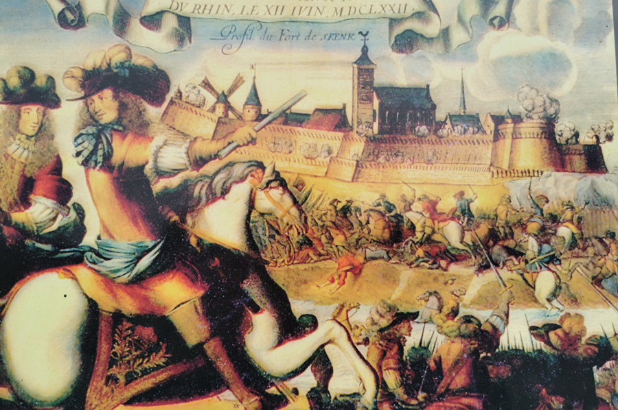
Even with the end of the war and the recognition of the independence of the United Netherlands in 1648, the dispute over the village did not end. At the beginning of the Dutch War in 1672, the 34-year-old French King Louis XIV personally stood at the gates with his troops. After a skirmish, the only 21-year-old commander had to capitulate. On May 1, 1674, the French withdrew and the troops of Electoral Brandenburg moved in. They stayed until the end of the war in 1679. Schenkenschanz then became Dutch again.
 At the end of the 17th century, the Lower Rhine was increasingly silting up and more and more water flowed into the Waal. In 1702, the Dutch government had a canal dug from the Waal bed to the Nederrijn near Millingen (the Pannerdens canal) to give the Nederrijn a stronger current. As a result, Schenkenschanz was drained and lost its strategic and military importance. The stronghold, which was hard fought for many decades, then developed into a peaceful and quiet place.
Please read as well:
Wadden area hike to bird protection island on Minsener Oldeoog
Stobi - archaeologists host during the campers' cultural trip