")
")
")
At Rennsteig long-distance hiking trail near Oberhof
- Written by Portal Editor

We have had the Rennsteig Tunnel several times, which at 7,916 meters is the longest road tunnel in Germany and the fourth longest twin-tube road tunnel in Europe after the Gran Sasso Tunnel, the Plabutsch Tunnel and the Seelisberg Tunnel.
We never had the time to take the descent to Oberhof, in order to at least get to the well-known and probably the first German long-distance hiking trail "Rennsteig". That should change now. As part of the A 71 Erfurt-Schweinfurt autobahn, between the Gräfenroda and Oberhof junctions (in Zella-Mehlis), the Rennsteig Tunnel crosses under the ridge of the Thuringian Forest with the Rennsteig ridge path. The Hochwald and Berg Bock tunnels follow immediately to the south, and the Alte Burg tunnel to the north. So today it should go in the direction of Oberhof and Rennsteig.
Depart Oberhof and stop at the Rodell obelisk
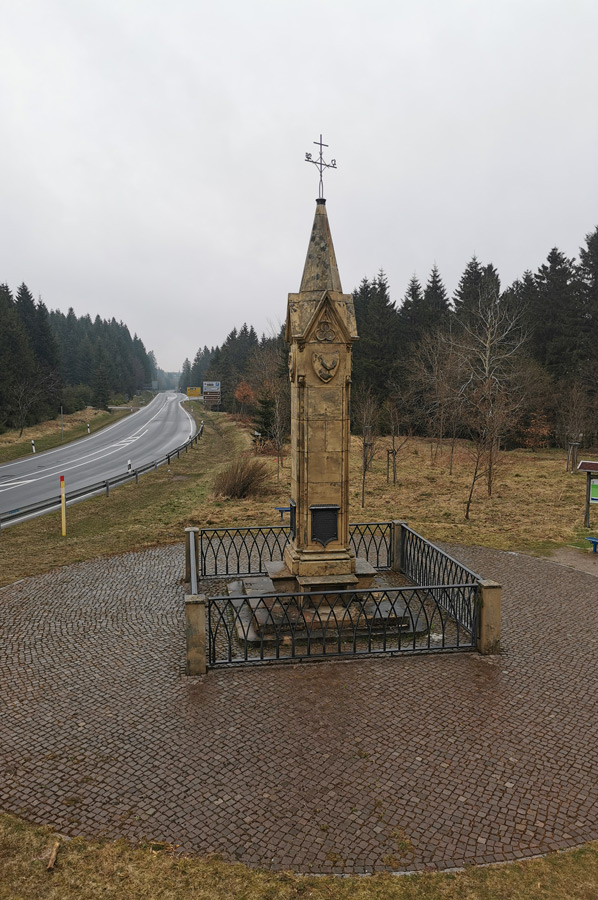 Driving a little later in the direction of Oberhof and despite the cloudy weather, we reached the large car park at the roundabout. The roundabout near Oberhof is actually a stone obelisk and thus a monument to the history of traffic at the intersection of the Thuringian state road 3247, the former federal road 247, with the Rennsteig, the ridge and about 170 km long ridge path and historical border path of the Thuringian Forest. The Rennsteig is also the oldest and, with around 100,000 hikers every year, the most frequented long-distance hiking trail in Germany. It begins in the Hörschel district of Eisenach on the banks of the Werra and ends in Blankenstein (Rosenthal am Rennsteig municipality) at the Selbitz Bridge. Its waymark is a white R.
The roundabout in turn is reminiscent of the road construction from 1830 to 1832, which the Gotha captain and road builder Julius von Plänckner managed. Duke Ernst I initiated the Gotha-Oberhof-Zella section in order to maintain a short connection between his duchies of Gotha and Coburg.
 The Kingdom of Prussia co-financed the road in order to have a connection to its exclaves, the districts of Schleusingen and Schmalkalden, for duty-free traffic. The roundabout is 826 meters above sea level.
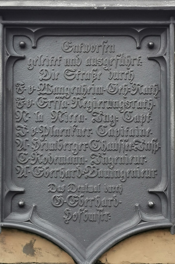
The seven meter high obelisk erected in 1834 was designed by the Gotha court architect Gustav Eberhard. Four inscriptions are attached. One has the names of those involved in road construction. The three other inscriptions read:
"How the road so surely and easily soars to the heights, Lands linked to lands, Commerce and arts animated."
"Hail to the creative mind, which turned the wilderness into a friendly garden and turned nature's terror into loveliness."
"Ernst Herzog zu Sachsen built this road to the height of the mountain 2572 par. feet in the years 1830=1832."
At Rondell - an important traffic junction since the Middle Ages
 From time immemorial, two important trade routes crossed the Rennsteig near Oberhof from north to south. The presumably older one ran via the Zellaer Leube to Zella, from there via Suhl, Hirschbach, Erlau to Schleusingen. A branch from Zella led to Rohr Abbey. The second old road led from Oberhof via the roundabout, the Suhler Leube, past the Großer Beerberg and the rest stop and inn Fröhlicher Mann to Suhl.
The expansion and maintenance of the road had been transferred in sections by the sovereigns to the towns of Suhl, Ohrdruf, Crawinkel, Wölfis, Zella-Mehlis, Benshausen, Heinrichs and Albrechts. The rights of escort mentioned in 1515 still belonged to the Thuringian landgrave. By 1536, Frederick of Saxony acquired all rights to tolls and escort rights, which his successors continued to claim until 1834. A long-overdue modernization of the streets as a chaussee or artificial street, which was associated with the funds, was only pushed ahead in 1832.
Hike to the Oberhof sports facilities despite the drizzle
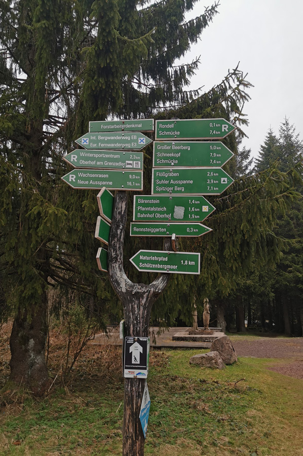
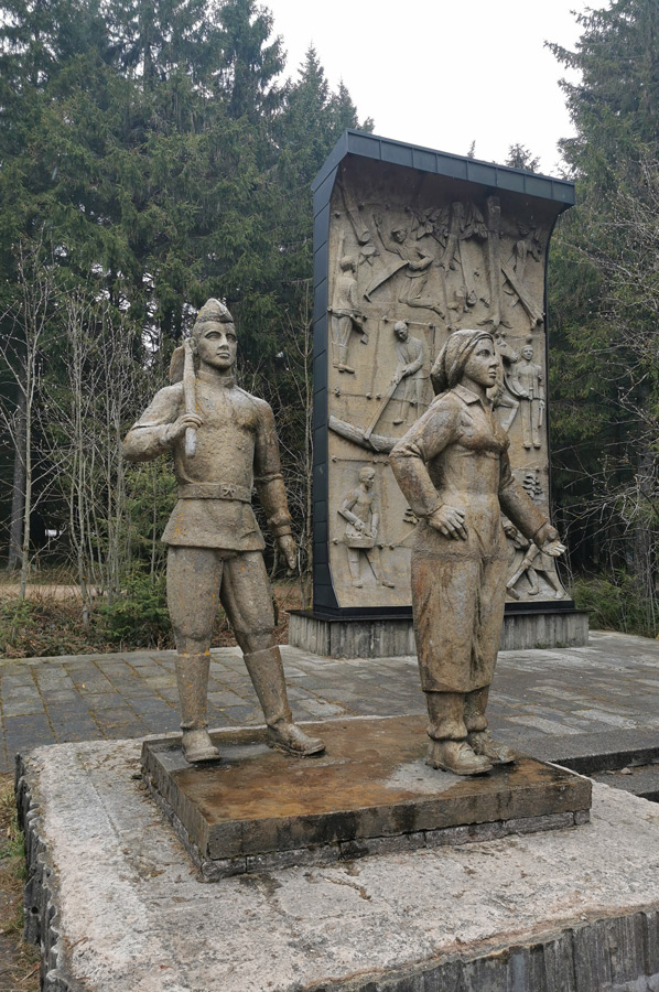 The roundabout is now an important landmark on the Rennsteig and the starting point for many hikes and of course known for the region for ski hikers and cross-country skiers, as well as for us as hikers. A bridge leads to the sports facilities of Oberhof, e.g. the biathlon stadium. Boards show hiking trails that lead to the sights in the area, so there was a monument to the reforestation of the Rennsteig ridge after terrible wind damage in the post-war years. Some of the leupes were still clearly visible because there was still a lot of snow left. So it went a few kilometers through the forest, every now and then we met the big R, the sign of the long-distance hiking trail. Unfortunately, it was becoming increasingly difficult to see into the biathlon stadium. We went to the restaurant in the huge parking lot of the stadium for physical strengthening, of course it should be a Thuringian bratwurst from the charcoal grill, which once again tasted delicious.
However, a charming landscape and the interest in further exploration was aroused, so that we will certainly return when the opportunity arises.
Please read as well:
Walser costume - explanations of the tradition in Mittelberg