Walk along the Main river - Albertshofen / Mainstockheim
Hiking trails lead to sights and viewpoints
In addition to routes that are suitable for day trips, the hiking organizations have also created and marked long-distance hiking trails that are divided into several daily stages. A special category of these routes are pilgrimage routes. The motivation to hike is subject to considerable fluctuations, both among different age groups and generations, as well as in terms of the type of hiking and the trend over time. While it was still a natural professional necessity with the journeyman trade, combined with experience, adventure and personal maturation, the generation of the youth movement and the wandering bird celebrated hiking in songs and undertakings as emancipation from the encrusted adult world, as an escape from the desolate cities’ romantic discovery of nature and as an indispensable part of their special youth culture. A study commissioned by the fitness magazine Fit for Fun from the Cologne Institute for Prevention and Aftercare (IPN) came to the conclusion that the energy expenditure when hiking is comparable to that when jogging. For example, the test subjects consumed as much food energy during a 2-hour hike in the lowlands as when jogging for 75 minutes. The gentle way is also said to be advantageous because the automatic pace adjustment rarely causes physical overstrain.
We had packed our backpacks with some provisions and something to drink quite early in the morning, because today we were going to the small mountain village of Garnbach near Wiehe, a distance of around 14 kilometres plus the return journey.
Finally – so many enthusiastic winter sports enthusiasts – it’s that time again. With the heavy snowfall of the last few days and the drop in snowfall depths to below 500 meters, the slopes and meadows in southern Germany are covered with snow again.
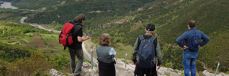
Coming into an area, that "virgin" is a relative good expression for, means a region that still seems to be relatively undeveloped, you are very grateful if you meet someone who has devoted precisely on this problem.
Once again, we were out with Ömer for our own physical exercise after a long winter in the Taurus, this time taking us to the mountain village of Sarihacilar. During a previous hike we came across the mountain village, which at that time only had a few inhabitants and most of the houses had collapsed and were abandoned.
Once again, the time had come - Ömer had invited people to hike a section of the Seljuk caravan route across the Taurus Mountains. Despite his many years of experience, which he had gained during the various routes through the Taurus between Manavgat and Akseki, the planned section was a first ascent for him too.
After our exploration tour through the Breitachklamm and further back through the truly natural Breitachtal, we go back until we come across a narrowing of the valley again in Riezlern.
As part of our project "Cultural journey along the Roman road system", the topic of mountain hiking is for us, in addition to attractive sports, outdoor and leisure activities for everyone, which can be carried out without large investments in equipment or local facilities, also an important topic that is meaning of the project could be successfully implemented elsewhere.
Unexpectedly, encounters that initially appear to be quite normal acquaintanceships, or how to describe them, often lead to deeper insights into comparable interests, perhaps even to a long-term relationship.
The eyes do not deceive, because it actually looks as if the water has divided and the visitor can walk over the water. The biblical saying of Moses became a reality!
After our recent visit to the Bastei Bridge, we also wanted to visit the town of Hohnstein, especially Hohnstein Castle as an attraction and Friends of Nature House and as a starting point for hiking and climbing tours in the Saxon Switzerland National Park.
Sucullu, a small town of 5.000 people on the St Paul Trail close to Antioch in Pisidia, is having a traditional folk festival. On 17th July, traditionally-dressed villagers with their animals will walk from the mosque in Yalvaç, past the ruins at Antioch, along the aqueduct to Sucullu (about 2-3 hrs walk).
Kate Clow first came to Turkey in 1989 to sell computer systems. In 1992 she moved to Antalya and, out of sheer interest, began researching the ancient roads that connected the cities of Greek and Roman times.
We had often passed the eye-catching dolomite rocks near Scharzfeld on our way through the Harz Mountains, and now there was finally enough time for a short hike up the rocks and on to the legendary "Unicorn Cave".
We were on our way back from Braunlage to Clausthal-Zellerfeld in the early afternoon when the wonderful sunshine, despite the forecast for rain, forced us to stop at the Oderteich car park.
A next Harz hiking destination was quickly found with the so-called World Forest, as well as other destinations in the Bad Grund area, so we also had the Albert Tower, the Hübichenstein and the quarry of the limestone mining area in mind.
Once again we were on a hiking tour in the Harz mountains, had already visited the Hübichenstein near Bad Grund and now wanted to go to the Harz hiking pin stamping point 129 to add another stamp to our hiking pass.
Today we have decided to visit the ruins of the Königsburg and the Königshütter waterfall in order, as announced, to fill our hiking pass with more stamps for the Harzer hiking pin.
As already reported in our article on the Harzer hiking needles, we had found increasing interest in the targeted hike to the multi-layered stamping points to the special highlights of the Harz hiking trails and thus also decided to equip ourselves with hiking passes and to supplement them with the various stamps.
 In addition to routes that are suitable for day trips, the hiking organizations have also created and marked long-distance hiking trails that are divided into several daily stages. A special category of these routes are pilgrimage routes.


