")
")
")
Beyşehir and the Unique Wooden Pillar Mosque
- Written by Portal Editor

Beyşehir - On our way from Manavgat towards Konya, we passed through the town of Beyşehir. We noticed the steady climb of the road along the way, so it was no surprise that we reached an altitude of 1,124 meters above sea level in the town itself.
Beyşehir is the second largest district in the Turkish province of Konya and also its capital city. The district has a total population of 118,144, of whom 41,312 live in the district center. The population density is only 27 inhabitants per square kilometer.
Beyşehir - The Largest Wooden Mosque in Turkey
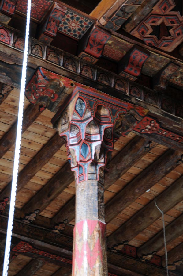
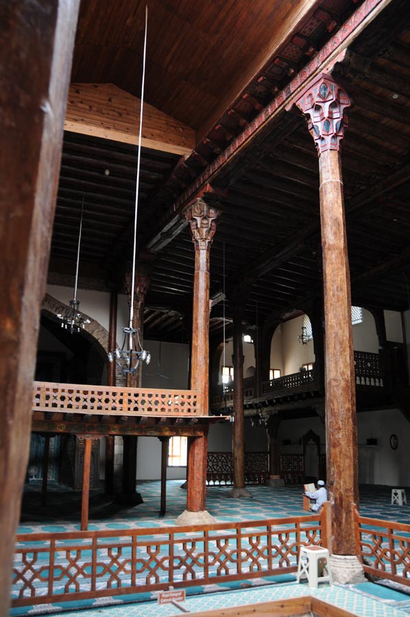
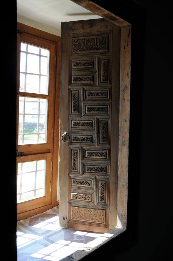
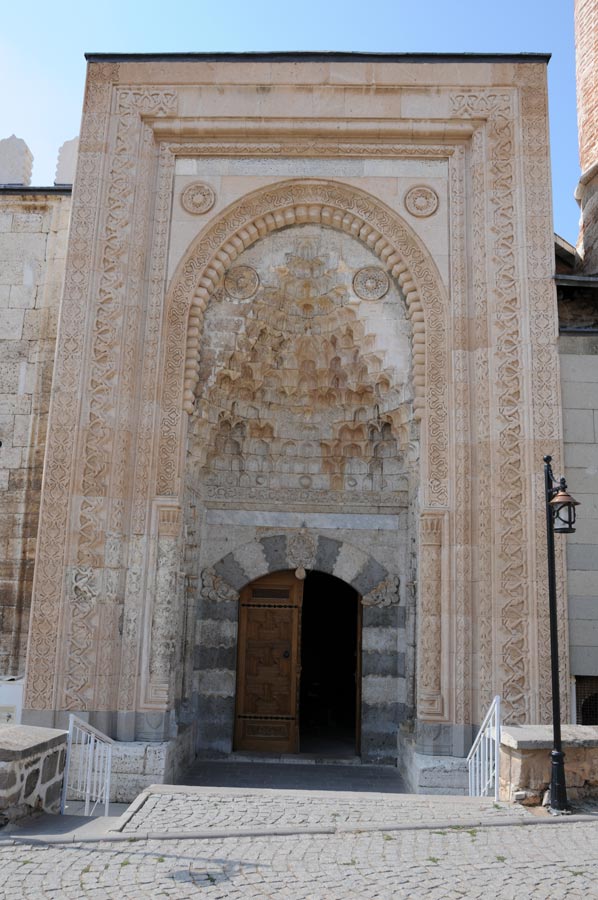 A must-see in Beyşehir is the Wooden Pillar Mosque, commissioned by Seyideddin Süleyman Bey in 1297, which is the largest wooden mosque in Turkey. The Eşrefoğlu Mosque is not only an impressive testament to Seljuk carpentry, but also incredibly rich in wood carvings. A total of 46 wooden columns with carved capitals divide the seven-aisled interior.
The columns, over 7 meters high, support a wooden beam ceiling, on which remnants of the old paintwork can still be seen. Light streams into the interior through the opening in the ceiling; the resulting square is called the "snow depot" (karlik). The area in front of the prayer niche is covered by a dome in typical Seljuk style, decorated with faience tiles and a band of inscriptions in Kufic script.
 Lake Beysehir begins right at the edge of the town. It covers an area of approximately 651 km² and has an average depth of 10 meters, depending on the water level and season.
Lake Beyşehir stretches for approximately 45 kilometers in length towards Seydisehir and is about 25 kilometers wide at its widest point. The entire area is surrounded by mountains reaching heights of up to 2,200 meters, which supply the lake with fresh water through rain and snowfall. The islands of İğdeli, Akburun, Kızkulesi, Mada, Yılanlı, and Külbent lie within Lake Beyşehir. Due to its abundant fish population, the lake is also a popular destination for sport fishermen from the coast.
Erbaba Tell (Turkish: Höyük) from the Neolithic Period
To irrigate the Konya Plain, a large water regulator is installed near the town of Beyşehir. Even in Ottoman times, the waters of the mountains west of Konya were used for an extensive irrigation system. Rivers were dammed, and the outflow of Lake Beyşehir was channeled to direct the water to the Konya region.
This irrigation project was further developed over the centuries and expanded into the first major irrigation project in the Middle East, financed by German banks and built by Dutch engineers.
Ten kilometers northwest of Beyşehir lies the Erbaba Tell (Turkish: Höyük). The tell is estimated to be 7,500 years old, dating back to the Neolithic period.
 This tell was discovered by the archaeologist R. Soleck and excavated in the 1970s under the direction of Jacques and Louise Alpes Bordaz. The tell has a diameter of approximately 80 meters. Four levels were uncovered at Erbaba. The lowest level yielded very few finds.
However, a number of artifacts were discovered on the third level. Stone blocks were used in the construction of the first, second, and third levels. The limestone walls, plastered in red, are over 60 cm thick and were joined with mud mortar.
About 20 km to the north lies the Hittite spring sanctuary of Eflatun Pınar, and 20 km to the east, the monument of Fasıllar, which is believed to be related. In the southwest of the lake are the remains of the Kubadabad Palace, built by the Seljuk Sultan Alaeddin Keykubat I between 1220 and 1235.
Please also read:
Pessinus - Sanctuary of the Mother Goddess Cybele
Binbir Kilisi - A Thousand Churches
-
 Beysehir - Esrefoglu Mosque
Beysehir - Esrefoglu Mosque
Beysehir - Esrefoglu Mosque
-
Beysehir - Esrefoglu Mosque
Beysehir - Esrefoglu Mosque
-
Beysehir - Esrefoglu Mosque
Beysehir - Esrefoglu Mosque
-
Beysehir - Esrefoglu Mosque
Beysehir - Esrefoglu Mosque
-
Beysehir - Esrefoglu Mosque
Beysehir - Esrefoglu Mosque
-
Beysehir - Esrefoglu Mosque
Beysehir - Esrefoglu Mosque
-
Beysehir - Esrefoglu Mosque
Beysehir - Esrefoglu Mosque
-
Beysehir - Esrefoglu Mosque
Beysehir - Esrefoglu Mosque
-
Beysehir - Esrefoglu Mosque
Beysehir - Esrefoglu Mosque
-
Beysehir - Esrefoglu Mosque
Beysehir - Esrefoglu Mosque
-
Beysehir - Esrefoglu Mosque
Beysehir - Esrefoglu Mosque
-
Beysehir - Esrefoglu Mosque
Beysehir - Esrefoglu Mosque
-
Beysehir - Esrefoglu Mosque
Beysehir - Esrefoglu Mosque
-
Beysehir - Esrefoglu Mosque
Beysehir - Esrefoglu Mosque
-
Beysehir - Esrefoglu Mosque
Beysehir - Esrefoglu Mosque
-
Beysehir - Esrefoglu Mosque
Beysehir - Esrefoglu Mosque
-
Beysehir - Esrefoglu Mosque
Beysehir - Esrefoglu Mosque
-
Beysehir - Esrefoglu Mosque
Beysehir - Esrefoglu Mosque
-
Beysehir - Esrefoglu Mosque
Beysehir - Esrefoglu Mosque
-
Beysehir - Esrefoglu Mosque
Beysehir - Esrefoglu Mosque
-
Beysehir - Esrefoglu Mosque
Beysehir - Esrefoglu Mosque
-
Beysehir - Esrefoglu Mosque
Beysehir - Esrefoglu Mosque
-
Beysehir - Esrefoglu Mosque
Beysehir - Esrefoglu Mosque
-
Beysehir - Esrefoglu Mosque
Beysehir - Esrefoglu Mosque


https://www.alaturka.info/en/turkey-country/centralanatolia/1737-beysehir-and-the-unique-wooden-pillar-mosque#sigProIde5659808f0