")
")
")
Limyra – The Roman Bridge of Ancient Zemuri
- Written by Portal Editor

Limyra - The Late Roman bridge near Limyra (Turkish: *Kırk Göz*, near Kemeri) in present-day southwestern Turkey is one of the oldest segmental arch bridges in the world.
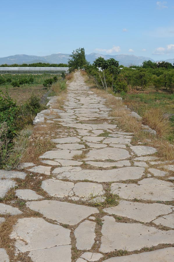
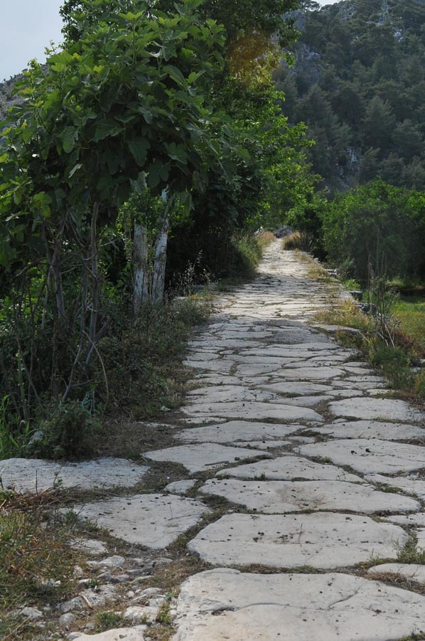
This 600-meter-long stone bridge spans the Alakır Çayı River near the ancient city of Limyra in Lycia.
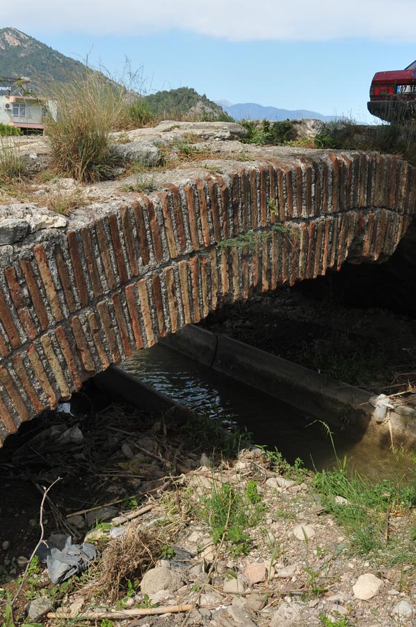
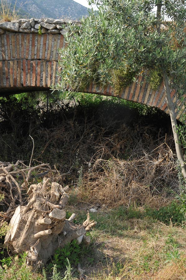
 Its 26 segmental arches, featuring a rise-to-span ratio of 5.3 to 1, lend the structure a remarkably flat profile—a design achievement in bridge engineering that remained unsurpassed for centuries and was not equalled again until the Late Middle Ages (see the Ponte Vecchio).
Despite its outstanding significance in the history of technology, the bridge at Limyra remains relatively unknown; the structure's progressive deterioration prompted the German Archaeological Institute (DAI) to conduct the only field investigation to date in the 1970s.
No accounts of the bridge have survived from antiquity. The first descriptions of the structure appear in European travelogues of the 19th century: during a visit in May 1840, Charles Fellows described the bridge as having 25 arches—a description echoed by Spratt and Forbes two years later.
Limyra Bridge – Published in the DAI’s *Archäologischer Anzeiger* in 1978
 In 1882, an Austrian expedition involving Otto Benndorf interpreted the structure as part of an ancient Roman road connecting Limyra to Antalya, located to the east. However, no plans or sketches were produced at that time.
The first—and to date, only—scientific survey of the bridge was conducted by Wolfgang Wurster and Joachim Ganzert over two consecutive days in September 1973, and was supplemented by further on-site visits over the following three years.
The results were published in 1978 in the *Archäologischer Anzeiger* of the DAI (German Archaeological Institute), explicitly to draw attention to the increasing threat facing the bridge, which had remained almost entirely intact until that time:
 “Recently, citrus plantations have been established in this fertile alluvial plain; to the east of the bridge, greenhouses for early-season vegetables are now being constructed. Due to the onset of intensive agriculture in the surrounding area, the bridge is at grave risk. Local residents are removing stone material from the bridge’s still-intact roadway; bulldozers used to excavate irrigation canals are tearing open the bridge structure and crushing the stone paving with their tracks.”
In 1993, the engineer O’Connor briefly summarized the DAI report in his English-language monograph on Roman bridge construction, likewise emphasizing the exceptional nature of the bridge. No further scholarly studies concerning the bridge near Limyra are known to exist.
See also the reports on the Eurymedon Bridge, the Cendere Bridge, and Roman bridge construction in modern-day Turkey!
Topography and Structural Design
 The Roman bridge spans the Alakır Çayı River 3.2 km east of the ruins of Limyra (measured from the theatre) and 3.8 km north of the present-day coastline, situated near the modern road connecting Turunçova and Kumluca; the ancient name of the river remains unknown. The local topography is defined by the foothills of the Toçak Dağı massif, which here transition into the flat alluvial plain of Finike Bay.
In this transitional zone, the bridge was constructed just upstream from the point where the narrow river valley opens out into the broad alluvial plain—a location where high waters during the rainy season would otherwise impede crossing. While the eastern end of the bridge tapers off into the gravel plain, its western end likely abuts directly against the rising bedrock, presumably as a safeguard against floodwaters. The sharp southward bend in the road necessitated by this alignment offered a strategic advantage, providing an ideal location for blocking the route. Today, the Alakır Çayı flows beneath only three of the Roman bridge's arches. Upstream, the modern Alakır Dam was constructed in recent times for irrigation and flood control purposes.
 In contrast to other Roman provinces, the ancient road network in Lycia was relatively underdeveloped. While north-south traffic primarily utilized the region's few river valleys, east-west routes—unlike those of today—typically traversed the mountain ridges. Among these routes, the path leading from Limyra across the Alakır Çayı into neighbouring Pamphylia, and onward to Attaleia, likely played a particularly significant role; indeed, until the 4th century AD, these two regions were administratively combined to form the single province of Lycia et Pamphylia.
Compared to the empire's major thoroughfares, the road connections in Lycia were—at a width of just 3 to 4 meters—of considerably more modest dimensions and were likely restricted to foot traffic and pack animals. This is further corroborated by the fact that the road surface of the bridge at Limyra bears no traces of wagon ruts; furthermore, no evidence of a railing or parapet could be detected on the structure itself.
Coordinates: 36°21'15.8"N 30°12'29.2"E (Link to map)
Please also read:
Simena - Ancient Site near the Village of Kaleköy
Saklıkent Canyon - an adventure of climbing & hiking
-
 Roman Bridge next to Limyra
Roman Bridge next to Limyra
Roman Bridge next to Limyra
-
Roman Bridge next to Limyra
Roman Bridge next to Limyra
-
Roman Bridge next to Limyra
Roman Bridge next to Limyra
-
Roman Bridge next to Limyra
Roman Bridge next to Limyra
-
Roman Bridge next to Limyra
Roman Bridge next to Limyra
-
Roman Bridge next to Limyra
Roman Bridge next to Limyra
-
Roman Bridge next to Limyra
Roman Bridge next to Limyra
-
Roman Bridge next to Limyra
Roman Bridge next to Limyra
-
Roman Bridge next to Limyra
Roman Bridge next to Limyra
-
Roman Bridge next to Limyra
Roman Bridge next to Limyra
-
Roman Bridge next to Limyra
Roman Bridge next to Limyra
-
Roman Bridge next to Limyra
Roman Bridge next to Limyra
-
Roman Bridge next to Limyra
Roman Bridge next to Limyra
-
Roman Bridge next to Limyra
Roman Bridge next to Limyra
-
Roman Bridge next to Limyra
Roman Bridge next to Limyra


https://www.alaturka.info/en/turkey-country/riviera/7117-limyra-roman-bridge-zemuri#sigProId4802c45ee5