")
")
")
Strasbourg – In the footsteps of the Romans
- Written by Portal Editor

Strasbourg - During our stay in Strasbourg, we had already collected some information about the Roman era of Strasbourg due to the visit to the Palais Rohan Museum.
We have already reported that the Roman general Drusus first set up a military outpost here on the Illinsel in 12 BC, which was given the name Argentoranum, which translates as "silver castle". In the immediate vicinity there was already a settlement of Belgian Gauls, also called Belgen, who were heavily interspersed with Germanic tribes and settled between the Seine and Marne and the Rhine.
Strasbourg - Gallic Wars by Julius Caesar
 The term Gauls was used at the time as a general term for the Celtic tribes on the territory of Gaul, which roughly corresponds to modern-day France, Belgium and the Swiss Mittelland.
Thus after the campaigns during the so-called Gallic War by Julius Caesar (from 58 - 51 BC) were the groups of Gauls reassigned to their settlement areas.
Thus, the Romans distinguished between Aquitanian Gauls (who belonged more to the Basque group than to those of the Celts), who inhabited roughly the region between the Pyrenees and the Garonne, and the Celtic Gauls or Celts between the Garonne and the Seine - Marne as well the documents already mentioned.
Strasbourg - The definition of these two axes
 The centre of the military camp was on the Illinsel, where the centre of Strasbourg is still located today. Almost without exception, all Roman camps are laid out on a main axis, which usually points in a north-south direction. The Romans themselves called this complex "Cardo", from which the orientation of the city resulted with the further development of the Roman camp into a city. The east-west direction was also defined as an axis perpendicular to this main axis, which was designated Decumanus. The centre of the camp or later city was therefore at the crossing point (locus gromae) of these two axes.
The determination of these two axes was something like a divine act, so that a priest was usually present at all times. Even the Romans had a kind of “leveling device” that enabled them to precisely determine the cardinal points. We have already reported about this device, called Groma. The secondary axes were then laid out for the two main axes "cardo maximus" and "decumus maximus", resulting in chessboard-like city plans that are still easily recognizable in excavations today. Since the Romans always first created the infrastructure in the form of fresh water supply and gray water disposal, the chessboard-like pattern in the location overlooking the surrounding area always had a double meaning. Even today in Strasbourg, the “cardo maximus” can be seen in the rue du Dôme and the “decumus maximus” in the rue des Hallebardes.
Strasbourg - Affected by major fires six times
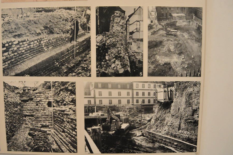
 Excavations could only be carried out on a larger scale in Strasbourg due to the severe destruction during the Second World War, which first documented the presence of the military camp and, due to the further excavations then carried out systematically in the years 1947 to 1953, revealed further details of the Roman history of Strasbourg.
Here it was particularly the excavations of Prof. Jean-Jacques Hatt, who also exactly document the evidence of the various major fires in the years 70, 97, 235, 355 as well as in the last quarter of the 4th century and in the first years of the 5th century could.
Altogether, the Argentoranum military camp, which had long since developed into a city, was hit by major fires six times and rebuilt six times.
Under the rule of the Roman Emperor Trajan and after the devastating fire of the year 97 AD, Argentoranum had reached its greatest extent and with it the strongest fortifications, which had long since developed from wooden palisades to stone fortifications.
Road from Augusta Vindelicorum to Argentoratum
 With the increasing expansion of the military camp, under the command of Gnaeus Pinarius Cornelius Clemens, the Legio VIII Augusta built a road from Augusta Vindelicorum (Augsburg) to Argentoranum (Strasbourg) in 74, which is now known as the "Kinzigtalstraße". Another road was created with the connection to the Rheintalstraße to Mobontiacum (Mainz). Numerous archaeological remains of the Roman settlement were found on the Roman road, now known as the Route des Romains, especially in the western district of Kœnigshoffen. From the numerous finds, one concludes today that this was probably the most densely populated place of the civilian population of the camp, which is also proven by the extensive necropolises. A researching predecessor of Hatt by the name of Robert Forrer had already dug in Kœnigshoffen in the years 1911-12 and uncovered numerous fragments of a large-scale mithraeum. It probably came from pre-Christian times and was then destroyed by the emerging Christians. Remains of the Mithraeum are in the Archaeological Museum of Strasbourg.
From about 90 AD, the Legio VIII was permanently stationed in Strasbourg. As already mentioned, after the major fire, it was rebuilt to an unprecedented size of around 20 hectares. In addition to the actual Legio VIII, a cavalry detachment was housed in the Argentoranum camp, temporarily also the Legio XIV Gemina and the Legio XXI Rapax, which was under the leadership of Nero.
Strasbourg – In the Footsteps of the Romans
 Strasbourg, the charming city in Alsace, is known for its medieval half-timbered houses, imposing cathedral, and picturesque canals. But few people know that the city also has a fascinating Roman past.
Over 2,000 years ago, the Romans built an important military camp here, laying the foundation for modern-day Strasbourg. Strolling through the city streets takes you on an exciting journey back in time to antiquity.
In this article, we explore the Roman traces in Strasbourg, from the remains of the ancient settlement to impressive finds in museums.
The Roman Foundation of Strasbourg – Argentoratum
1. A Strategic Military Base
- Strasbourg was an important Roman military base known as Argentoratum.
- It was founded in the 1st century BC during Julius Caesar's conquest of Gaul.
- Its location on the River Ill made it a strategically important defensive point.
2. Life in Argentoratum
- The camp served as a base for the Legio VIII Augusta, one of the Roman elite units.
- A civilian settlement with artisans, traders, and Roman citizens developed around the military camp.
- There were thermal baths, temples, and a forum that shaped the Roman cityscape.
3. The Roman Roads and Their Significance
- Argentoratum was an important hub in the Roman road network.
- The Via Agrippa, an important trade route, ran through the area.
- Today, remnants of these ancient roads are still visible in some parts of the city.
Archaeological Discoveries – What Remains of the Romans?
 Even though Strasbourg is better known today for its medieval old town, numerous Roman traces can still be found.
1. Remains of the Roman Camp
- Archaeological excavations have uncovered the foundations of Roman buildings.
- Sections of the old city walls and floor plans of Roman barracks were discovered.
- Some of these relics can be viewed today in various parts of the city.
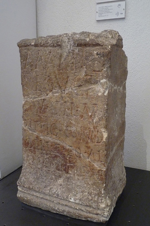
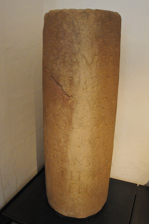
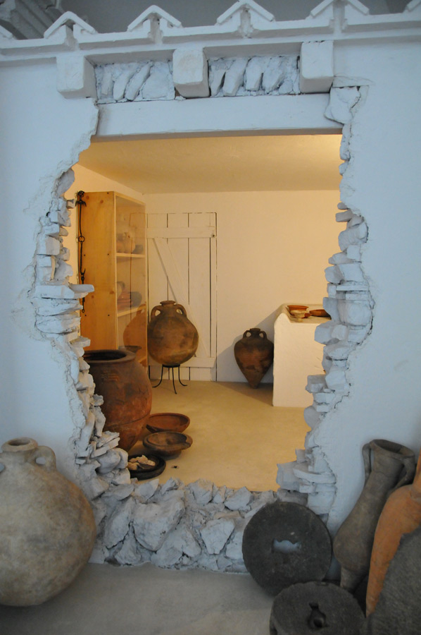
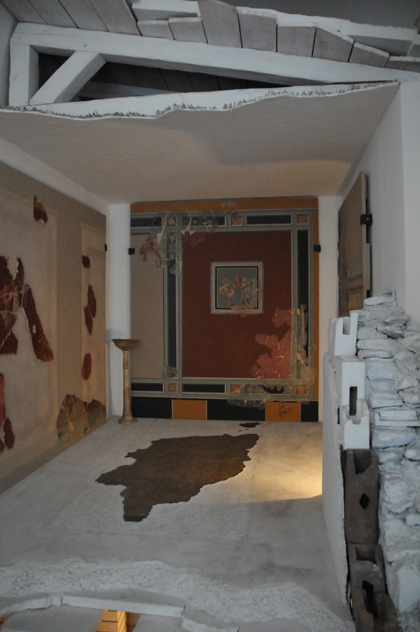
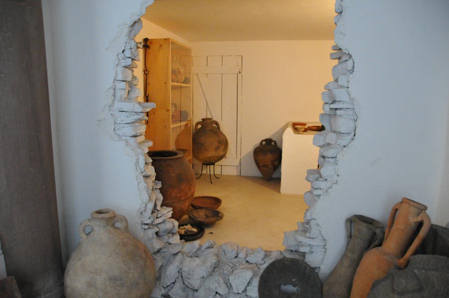
2. Roman finds at the Musée Archéologique
- The Strasbourg Archaeological Museum displays an impressive collection of Roman artifacts.
- Highlights include Roman statues, coins, weapons, and everyday objects.
- Particularly worth seeing: a Roman funerary stele with Latin inscriptions.
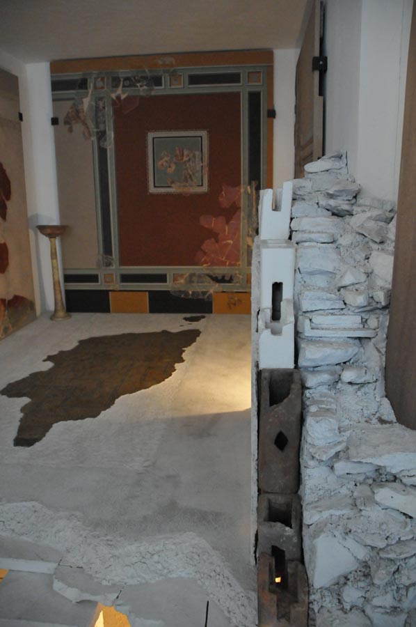
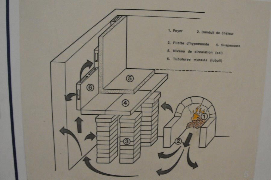
3. Thermal Baths and Roman Baths
- Roman bathhouses existed near today's Strasbourg Cathedral.
- These were discovered in the 1980s and provide fascinating insights into ancient life.
- The thermal baths were an important social gathering place for society at the time.
Experience Strasbourg's Roman Past - The Best Places
 For history buffs, there are numerous places in Strasbourg where you can discover the Roman past.
1. The Strasbourg Archaeological Museum
- Perfect for those interested in ancient finds and Roman history.
- Located in the Palais Rohan near the cathedral.
2. The Remains of the Roman Forum
- Some traces of the Roman forum are still visible.
- It was located near today's Place Broglie.
3. Remains of the Roman City Walls
- Part of the old Roman city wall can still be found near Rue des Juifs.
4. Walk along the former Roman roads
- A walk along the historic Roman paths in the old town is particularly exciting.
How did the Roman period influence modern-day Strasbourg?
 Although the Roman buildings have largely disappeared, the Roman era left deep traces in the city's structure.
✔ Road network – Some streets still follow the main Roman routes.
✔ Naming – The Latin name Argentoratum has been preserved in the city's coat of arms and street names.
✔ Construction – Parts of the medieval city were built on Roman foundations.
✔ Cultural heritage – Roman traditions influenced the way of life and architecture of the following centuries.
Conclusion – Strasbourg's fascinating Roman heritage
 Strasbourg is a city with many faces – and its Roman past is an often overlooked but exciting part of its history.
From the ancient streets to the finds in the Archaeological Museum, there are many ways to experience Roman times firsthand. Anyone interested in history should definitely follow in the footsteps of the Romans through Strasbourg!
Frequently Asked Questions (FAQs)
1. When was Strasbourg founded by the Romans?
Strasbourg was founded as Argentoratum in the 1st century BC and served as a Roman military camp.
2. Are there still visible remains of the Roman city?
Yes, there are still some foundations, remains of walls, and sections of streets dating back to Roman times.
 3. Where can you see Roman artifacts in Strasbourg?
The Musée Archéologique in the Palais Rohan houses a large collection of Roman finds.
4. What was the significance of Argentoratum to the Roman Empire?
Argentoratum was an important military base and a major trading center on the border of the Roman Empire.
5. Is it possible to take a guided tour of the Roman sites?
Yes, there are guided tours of Strasbourg that include Roman sites and archaeological finds.
Planning a trip to Strasbourg? Then discover the traces of the Romans and immerse yourself in the fascinating history of this unique city!
Please read as well:
Excavation and Conservation Works in Stobi, Macedonia
Aventicum - Amphitheatre and Roman Theatre awaiting us
-
 Strasbourg - Roman Museum
Strasbourg - Roman Museum
Strasbourg - Roman Museum
-
Strasbourg - Roman Museum
Strasbourg - Roman Museum
-
Strasbourg - Roman Museum
Strasbourg - Roman Museum
-
Strasbourg - Roman Museum
Strasbourg - Roman Museum
-
Strasbourg - Roman Museum
Strasbourg - Roman Museum
-
Strasbourg - Roman Museum
Strasbourg - Roman Museum


https://www.alaturka.info/en/roman-road-project/5787-strasbourg-in-the-footsteps-of-the-romans#sigProId3ac15fe7d3