Ancient Roman Roads in Turkey - Still to find today

Roman long-distance roads were used not only by merchants but, above all, by soldiers, government officials traveling between Rome and their posts in the provinces, and imperial couriers transporting messages and letters (cursus publicus).
They formed a network of routes that spanned the entire Roman Empire. They were built primarily for political and military reasons, designed to make provinces and other territories annexed by the Empire quickly and easily accessible.
 The subsequent expansion of the road network for commercial purposes paralleled the growth of the Empire. Until toward the end of the 4th century BC, most Roman roads consisted of unpaved tracks.
It was only later that they began to be paved, as these military roads were essential for the Empire’s territorial expansion.
Approaching from present-day Greece, Byzantium (Constantinople/Istanbul) served as the starting point for the Roman road system in what is now Turkey.
 One major route ran eastward along the Black Sea coast, passing through the cities of Sinope (Sinop) and Trapezus (Trabzon). Another route led through Pergamon, Smyrna (Izmir), Sardes, Tarsus, and Antioch, continuing as far as Alexandria and Memphis in present-day Egypt.
Along these roads, travellers and couriers could consult milestones to determine the distance to the next station or settlement. Distances were indicated in miles (one Roman mile = 1,478 meters).
These stones also frequently bore the name of the emperor who had been responsible for the development or expansion of the road. Thanks to a network of Roman roads and numerous relay stations used, among other things, for changing horses the imperial postal service could cover approximately 200 km in a single day. A journey from Mainz to Cologne, for instance, took one day, while the trip from Mainz to Rome took only 10 days.
 The extensive road network throughout the Roman Empire spanned approximately 80,000 km.
A Roman road featured a substructure up to 1 meter thick, composed of several layers. The base consisted of rammed clay, topped by the *statumen* a layer of limestone bound with mortar for stability.
The next layer, the ruderatio, consisted of fist-sized pebbles, followed by a layer of nut-sized pebbles known as the *nucleus*. On major long-distance routes, on inclines, or in sections requiring extra protection against the elements, the road surface was finished with cobblestones or precisely cut stone slabs.
In other areas, the top layer consisted of course, firmly rolled or rammed gravel or sand. The road surface was rounded toward the sides, allowing surface water to drain quickly into lateral gutters. Water flowing down slopes was channelled beneath the roads to prevent uncontrolled erosion of the road foundation.
Via Egnatia
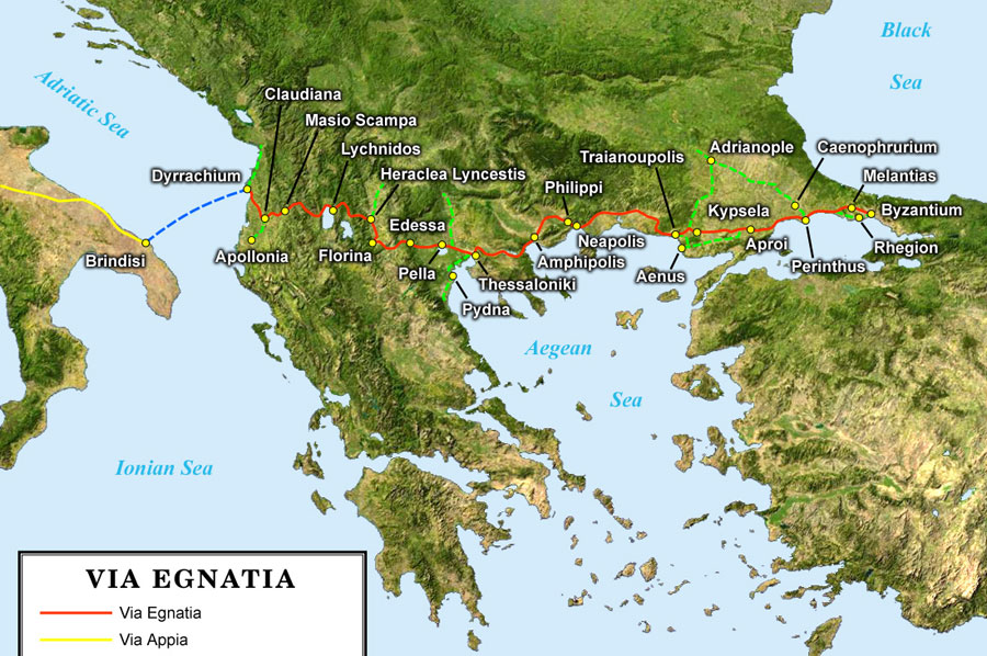 Built in the 2nd century BC by the proconsul Gaius Egnatius, this road ran from Dyrrachium (Durrës, Albania) through Edessa (Greece), Thessaloniki (Greece), Amphipolis (Greece), and Kypsela (Turkey) to Constantinople (Istanbul, Turkey).
Serving as an extension of the Via Appia—connected via the sea route from Brindisi to Durrës this road functioned as the link between Rome and Constantinople. With the kind support of
Bernd Liermann
Please also read:
Arch of Galerius – a late Roman triumphal arch in Thessaloniki
Cendere Köprüsü – the bridge over the Chabinas